Maghār elevation
Maghār (Northern District), Israel elevation is 292 meters and Maghār elevation in feet is 958 ft above sea level [src 1]. Maghār is a populated place (feature code) with elevation that is 81 meters (266 ft) bigger than average city elevation in Israel.
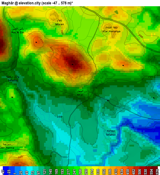
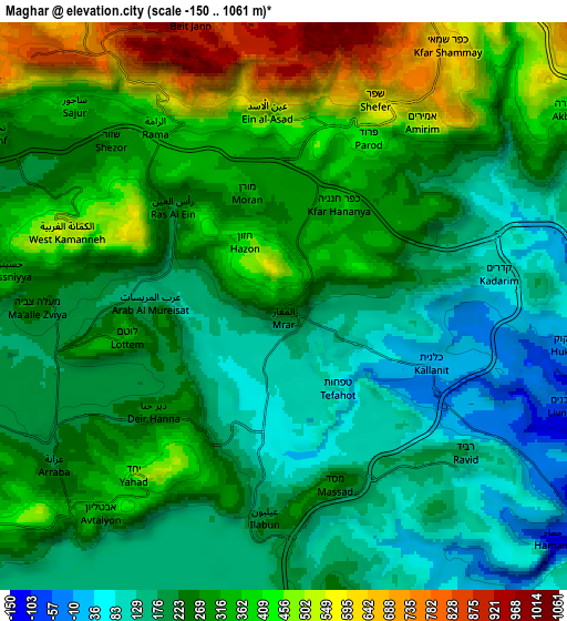
Below is the Elevation map of Maghār, which displays elevation range with different colors. Scale of the first map is from -47 to 578 m (-154 to 1896 ft) with average elevation of 210.7 meters (=691 ft) [note 1]
These maps also provides idea of topography and contour of this city, they are displayed at different zoom levels. More info about maps, scale and edge coordinates you can find below images.
| \ | Map #1 | Map #2 | Topo.Map |
| Scale [m] | -47..578 m | -150..1061 m | × |
| Scale [ft] | -154..1896 ft | -492..3481 ft | × |
| Average | 210.7 m = 691 ft | 275.4 m = 904 ft | × |
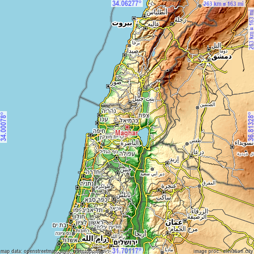
| Width | 8.21 km = 5.1 mi | 16.41 km = 10.2 mi | 262.6 km = 163.2 mi |
| Height | 8.21 km = 5.1 mi | 16.41 km = 10.2 mi | 262.6 km = 163.2 mi |
| ↑Max Latitude | 32.926734° | 32.963612° | 34.06277° |
| Latitude at center | 32.88984° | 32.88984° | 32.88984° |
| ↓Min Latitude | 32.852931° | 32.816006° | 31.70117° |
| ← Min Longitude | 35.363085° | 35.319139° | 34.00078° |
| Longitude center | 35.40703° | 35.40703° | 35.40703° |
| →Max Longitude | 35.450975° | 35.494921° | 36.81328° |
Nearby cities:
Cities around Maghār sort by population:
• Karmi’el elevation 233 m
10 km,  287°
287°
• Safed 779 m
11.8 km,  44°
44°
• Sakhnīn 236 m
10.7 km,  254°
254°
• Naḥf 326 m
9.8 km,  300°
300°
• Beit Jann 923 m
8.7 km,  344°
344°
• Deir Ḥannā 289 m
5.1 km,  232°
232°
• Bu‘eina 238 m
10.1 km,  202°
202°
• Buqei‘a 565 m
11.9 km,  324°
324°
• ‘Eilabun 187 m
5.9 km,  186°
186°
• Sājūr 375 m
8.5 km,  313°
313°
• ‘Uzeir 166 m
13 km,  213°
213°
• Sallama 172 m
3.6 km,  278°
278°
Multilingual:
 En español:
Maghār elevación 292 m.
 En France:
Maghār élévation 292 m.


Sources and notes:
- [note 1] Map square and city borders are not equal. Map elevation data is calculated only from area inside that square.
- [src 1] Elevation data from geonames database provided with same terms of usage.
- [src 2] The elevation map of Maghār is generated using elevation data from NASA's 3 arcsec (90m) resolution SRTM data.
- [src 3] Base (background) map © OpenStreetMap contributors tiles are generated by Geofabrik and OpenTopoMap.
Copyright & License:
This Maghār Elevation Map is licensed under CC BY-SA. You may reuse any part from this page, if you give a proper credit by linking to this URL:
 More info on terms of use page.