Beit Jann elevation
Beit Jann (Northern District), Israel elevation is 923 meters and Beit Jann elevation in feet is 3028 ft above sea level [src 1]. Beit Jann is a populated place (feature code) with elevation that is 712 meters (2336 ft) bigger than average city elevation in Israel.
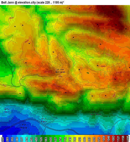
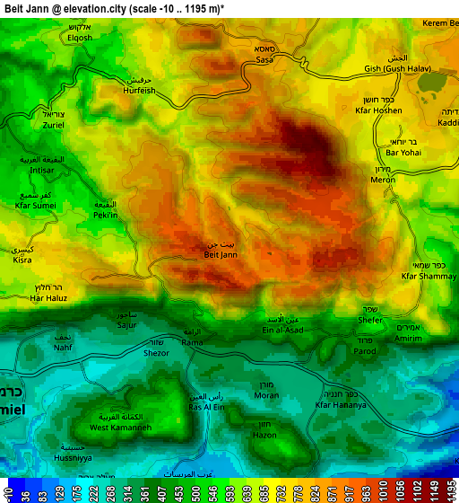
Below is the Elevation map of Beit Jann, which displays elevation range with different colors. Scale of the first map is from 228 to 1195 m (748 to 3921 ft) with average elevation of 757.4 meters (=2485 ft) [note 1]
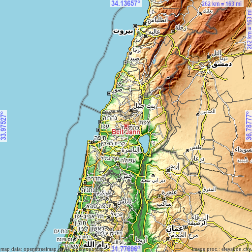
These maps also provides idea of topography and contour of this city, they are displayed at different zoom levels. More info about maps, scale and edge coordinates you can find below images.
| \ | Map #1 | Map #2 | Topo.Map |
| Scale [m] | 228..1195 m | -10..1195 m | × |
| Scale [ft] | 748..3921 ft | -33..3921 ft | × |
| Average | 757.4 m = 2485 ft | 594.2 m = 1949 ft | × |
| Width | 8.2 km = 5.1 mi | 16.4 km = 10.2 mi | 262.4 km = 163 mi |
| Height | 8.2 km = 5.1 mi | 16.4 km = 10.2 mi | 262.4 km = 163 mi |
| ↑Max Latitude | 33.001503° | 33.03835° | 34.13657° |
| Latitude at center | 32.96464° | 32.96464° | 32.96464° |
| ↓Min Latitude | 32.927762° | 32.890868° | 31.77696° |
| ← Min Longitude | 35.337575° | 35.293629° | 33.97527° |
| Longitude center | 35.38152° | 35.38152° | 35.38152° |
| →Max Longitude | 35.425465° | 35.469411° | 36.78777° |
Nearby cities:
Cities around Beit Jann sort by population:
• Karmi’el elevation 233 m
8.9 km,  233°
233°
• Safed 779 m
10.7 km,  89°
89°
• Maghār 292 m
8.7 km,  164°
164°
• Naḥf 326 m
6.9 km,  240°
240°
• Deir Ḥannā 289 m
11.5 km,  188°
188°
• Kefar Weradim 629 m
10.2 km,  288°
288°
• Ḥurfeish 657 m
6.6 km,  332°
332°
• Buqei‘a 565 m
4.7 km, 287°
• Sājūr 375 m
4.5 km, 236°
• Pasuta 639 m
11.6 km,  324°
324°
• Jīsh 765 m
8.8 km,  43°
43°
• Sallama 172 m
7.9 km, 188°
Multilingual:
 En español:
Beit Jann elevación 923 m.
 En France:
Beit Jann élévation 923 m.
 Auf Deutsch:
Beit Jann höhe über dem Meeresspiegel ist 923 m.

Sources and notes:
- [note 1] Map square and city borders are not equal. Map elevation data is calculated only from area inside that square.
- [src 1] Elevation data from geonames database provided with same terms of usage.
- [src 2] The elevation map of Beit Jann is generated using elevation data from NASA's 3 arcsec (90m) resolution SRTM data.
- [src 3] Base (background) map © OpenStreetMap contributors tiles are generated by Geofabrik and OpenTopoMap.
Copyright & License:
This Beit Jann Elevation Map is licensed under CC BY-SA. You may reuse any part from this page, if you give a proper credit by linking to this URL:
 More info on terms of use page.