Fīq elevation
Fīq (Northern District), Israel elevation is 330 meters and Fīq elevation in feet is 1083 ft above sea level [src 1]. Fīq is a seat of a second-order administrative division (feature code) with elevation that is 119 meters (390 ft) bigger than average city elevation in Israel.
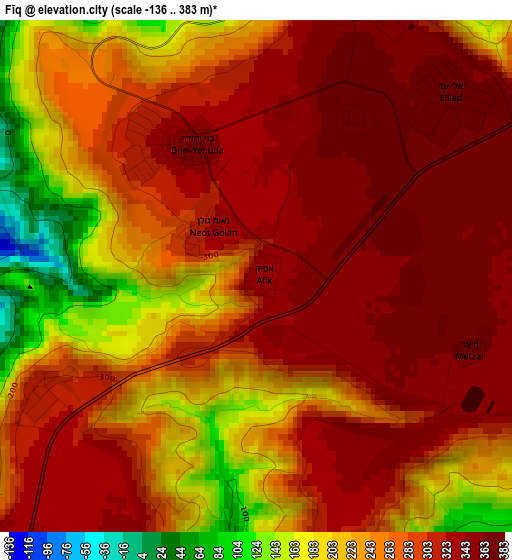
Below is the Elevation map of Fīq, which displays elevation range with different colors. Scale of the first map is from -136 to 383 m (-446 to 1257 ft) with average elevation of 278 meters (=912 ft) [note 1]
These maps also provides idea of topography and contour of this city, they are displayed at different zoom levels. More info about maps, scale and edge coordinates you can find below images.
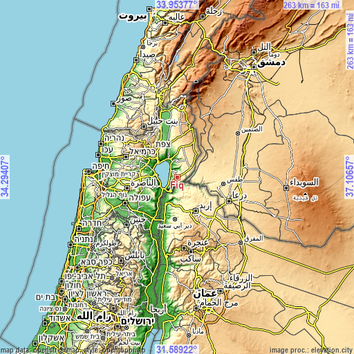
| \ | Map #1 | Topo.Map |
| Scale [m] | -136..383 m | × |
| Scale [ft] | -446..1257 ft | × |
| Average | 278 m = 912 ft | × |
| Width | 8.22 km = 5.1 mi | 262.9 km = 163.4 mi |
| Height | 8.22 km = 5.1 mi | 262.9 km = 163.4 mi |
| ↑Max Latitude | 32.81629° | 33.95377° |
| Latitude at center | 32.77935° | 32.77935° |
| ↓Min Latitude | 32.742395° | 31.58922° |
| ← Min Longitude | 35.656375° | 34.29407° |
| Longitude center | 35.70032° | 35.70032° |
| →Max Longitude | 35.744265° | 37.10657° |
Nearby cities:
Cities around Fīq sort by population:
• Tiberias elevation -140 m
15.9 km,  275°
275°
• Safed 779 m
28.1 km,  317°
317°
• Maghār 292 m
30 km,  294°
294°
• Shibli 234 m
30.3 km,  251°
251°
• ‘Eilabun 187 m
28.8 km, 282°
• Kafr Kammā 228 m
25.1 km,  255°
255°
• Yavne’el -18 m
20.1 km, 246°
• Rosh Pinna 391 m
25.7 km,  325°
325°
• Kafr Miṣr 122 m
30.1 km,  240°
240°
• Kefar Tavor 118 m
28.1 km, 248°
• Al Khushnīyah 763 m
26.6 km,  22°
22°
• Al Buţayḩah -193 m
15.7 km,  336°
336°
Multilingual:
 En español:
Fīq elevación 330 m.
 En France:
Fīq élévation 330 m.


Sources and notes:
- [note 1] Map square and city borders are not equal. Map elevation data is calculated only from area inside that square.
- [src 1] Elevation data from geonames database provided with same terms of usage.
- [src 2] The elevation map of Fīq is generated using elevation data from NASA's 3 arcsec (90m) resolution SRTM data.
- [src 3] Base (background) map © OpenStreetMap contributors tiles are generated by Geofabrik and OpenTopoMap.
Copyright & License:
This Fīq Elevation Map is licensed under CC BY-SA. You may reuse any part from this page, if you give a proper credit by linking to this URL:
 More info on terms of use page.