Bojonegoro elevation
Bojonegoro (East Java), Indonesia elevation is 24 meters and Bojonegoro elevation in feet is 79 ft above sea level [src 1]. Bojonegoro is a seat of a second-order administrative division (feature code) with elevation that is 167 meters (548 ft) smaller than average city elevation in Indonesia.
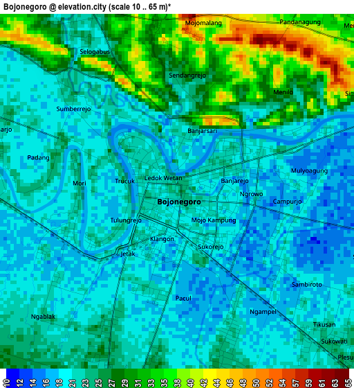
Below is the Elevation map of Bojonegoro, which displays elevation range with different colors. Scale of the first map is from 10 to 65 m (33 to 213 ft) with average elevation of 23.6 meters (=77 ft) [note 1]
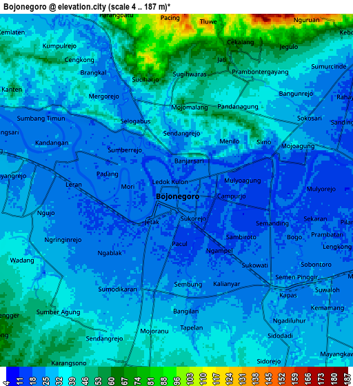
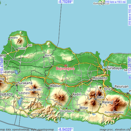
These maps also provides idea of topography and contour of this city, they are displayed at different zoom levels. More info about maps, scale and edge coordinates you can find below images.
| \ | Map #1 | Map #2 | Topo.Map |
| Scale [m] | 10..65 m | 4..187 m | × |
| Scale [ft] | 33..213 ft | 13..614 ft | × |
| Average | 23.6 m = 77 ft | 33.6 m = 110 ft | × |
| Width | 9.7 km = 6 mi | 19.39 km = 12 mi | 310.3 km = 192.8 mi |
| Height | 9.7 km = 6 mi | 19.39 km = 12 mi | 310.3 km = 192.8 mi |
| ↑Max Latitude | -7.106594° | -7.062985° | -5.75289° |
| Latitude at center | -7.1502° | -7.1502° | -7.1502° |
| ↓Min Latitude | -7.193801° | -7.237399° | -8.54325° |
| ← Min Longitude | 111.837755° | 111.793809° | 110.47545° |
| Longitude center | 111.8817° | 111.8817° | 111.8817° |
| →Max Longitude | 111.925645° | 111.969591° | 113.28795° |
Nearby cities:
Cities around Bojonegoro sort by population:
• Tuban elevation 13 m
34.6 km,  35°
35°
• Cepu 36 m
32.1 km,  270°
270°
• Babat 12 m
31.4 km,  82°
82°
• Latsari 11 m
33.9 km,  32°
32°
• Gedongombo 22 m
33.5 km, 37°
• Bejagung Kidul 37 m
32.5 km, 38°
• Merakurak 9 m
32.4 km,  20°
20°
• Pengkok 33 m
30 km, 266°
• Kerek 68 m
28.4 km,  1°
1°
• Bangilan 54 m
27.3 km,  317°
317°
• Senori 55 m
22.9 km,  310°
310°
• Jojogan 59 m
22.5 km,  332°
332°
Multilingual:
 En español:
Bojonegoro elevación 24 m.
 En France:
Bojonegoro élévation 24 m.
 Auf Deutsch:
Bojonegoro höhe über dem Meeresspiegel ist 24 m.

Sources and notes:
- [note 1] Map square and city borders are not equal. Map elevation data is calculated only from area inside that square.
- [src 1] Elevation data from geonames database provided with same terms of usage.
- [src 2] The elevation map of Bojonegoro is generated using elevation data from NASA's 3 arcsec (90m) resolution SRTM data.
- [src 3] Base (background) map © OpenStreetMap contributors tiles are generated by Geofabrik and OpenTopoMap.
Copyright & License:
This Bojonegoro Elevation Map is licensed under CC BY-SA. You may reuse any part from this page, if you give a proper credit by linking to this URL:
 More info on terms of use page.