Jojogan elevation
Jojogan (East Java), Indonesia elevation is 59 meters and Jojogan elevation in feet is 194 ft above sea level [src 1]. Jojogan is a seat of a third-order administrative division (feature code) with elevation that is 132 meters (433 ft) smaller than average city elevation in Indonesia.
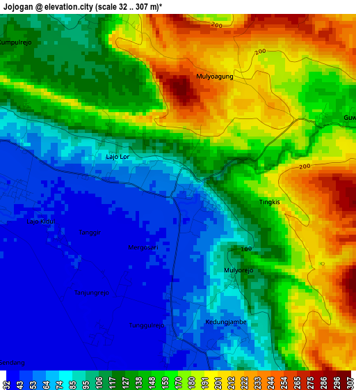
Below is the Elevation map of Jojogan, which displays elevation range with different colors. Scale of the first map is from 32 to 307 m (105 to 1007 ft) with average elevation of 125.4 meters (=411 ft) [note 1]
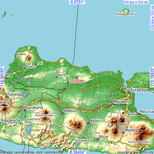
These maps also provides idea of topography and contour of this city, they are displayed at different zoom levels. More info about maps, scale and edge coordinates you can find below images.
| \ | Map #1 | Topo.Map |
| Scale [m] | 32..307 m | × |
| Scale [ft] | 105..1007 ft | × |
| Average | 125.4 m = 411 ft | × |
| Width | 9.7 km = 6 mi | 310.4 km = 192.9 mi |
| Height | 9.7 km = 6 mi | 310.4 km = 192.9 mi |
| ↑Max Latitude | -6.927278° | -5.5731° |
| Latitude at center | -6.9709° | -6.9709° |
| ↓Min Latitude | -7.014518° | -8.36454° |
| ← Min Longitude | 111.744155° | 110.38185° |
| Longitude center | 111.7881° | 111.7881° |
| →Max Longitude | 111.832045° | 113.19435° |
Nearby cities:
Cities around Jojogan sort by population:
• Bojonegoro elevation 24 m
22.5 km,  152°
152°
• Cepu 36 m
29.3 km,  227°
227°
• Pengkok 33 m
29.3 km,  222°
222°
• Merakurak 9 m
24.2 km,  64°
64°
• Sale 101 m
23.6 km,  300°
300°
• Bancar 23 m
20.9 km,  357°
357°
• Jamong 9 m
20.2 km,  21°
21°
• Jetis 79 m
19 km,  290°
290°
• Jatirogo 70 m
17.1 km, 303°
• Kerek 68 m
13.8 km,  52°
52°
• Senori 55 m
8.6 km, 234°
• Bangilan 54 m
8.2 km,  270°
270°
Multilingual:
 En español:
Jojogan elevación 59 m.
 En France:
Jojogan élévation 59 m.


Sources and notes:
- [note 1] Map square and city borders are not equal. Map elevation data is calculated only from area inside that square.
- [src 1] Elevation data from geonames database provided with same terms of usage.
- [src 2] The elevation map of Jojogan is generated using elevation data from NASA's 3 arcsec (90m) resolution SRTM data.
- [src 3] Base (background) map © OpenStreetMap contributors tiles are generated by Geofabrik and OpenTopoMap.
Copyright & License:
This Jojogan Elevation Map is licensed under CC BY-SA. You may reuse any part from this page, if you give a proper credit by linking to this URL:
 More info on terms of use page.