Jatiroto elevation
Jatiroto (Central Java), Indonesia elevation is 265 meters and Jatiroto elevation in feet is 869 ft above sea level [src 1]. Jatiroto is a populated place (feature code) with elevation that is 74 meters (243 ft) bigger than average city elevation in Indonesia.
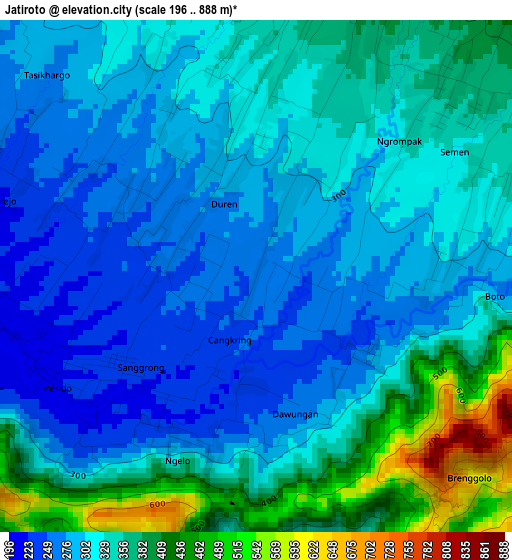
Below is the Elevation map of Jatiroto, which displays elevation range with different colors. Scale of the first map is from 196 to 888 m (643 to 2913 ft) with average elevation of 329.7 meters (=1082 ft) [note 1]
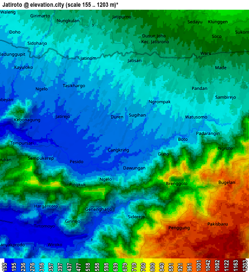
These maps also provides idea of topography and contour of this city, they are displayed at different zoom levels. More info about maps, scale and edge coordinates you can find below images.
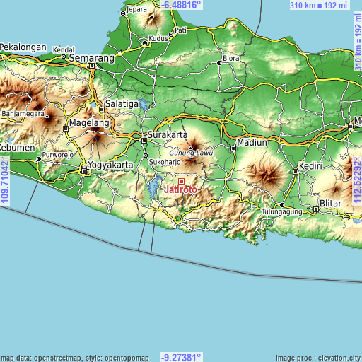
| \ | Map #1 | Map #2 | Topo.Map |
| Scale [m] | 196..888 m | 155..1203 m | × |
| Scale [ft] | 643..2913 ft | 509..3947 ft | × |
| Average | 329.7 m = 1082 ft | 442.7 m = 1452 ft | × |
| Width | 9.68 km = 6 mi | 19.36 km = 12 mi | 309.7 km = 192.4 mi |
| Height | 9.68 km = 6 mi | 19.36 km = 12 mi | 309.8 km = 192.5 mi |
| ↑Max Latitude | -7.839798° | -7.796261° | -6.48816° |
| Latitude at center | -7.88333° | -7.88333° | -7.88333° |
| ↓Min Latitude | -7.926858° | -7.970381° | -9.27381° |
| ← Min Longitude | 111.072725° | 111.028779° | 109.71042° |
| Longitude center | 111.11667° | 111.11667° | 111.11667° |
| →Max Longitude | 111.160615° | 111.204561° | 112.52292° |
Nearby cities:
Cities around Jatiroto sort by population:
• Grogol elevation 93 m
45.4 km,  313°
313°
• Ponorogo 103 m
38.1 km,  87°
87°
• Jaten 113 m
41.7 km,  324°
324°
• Selogiri 117 m
29.7 km,  291°
291°
• Ngrayun 528 m
42.2 km,  119°
119°
• Bungkal 131 m
39.7 km,  110°
110°
• Sukoharjo 103 m
38.6 km, 307°
• Karanganyar 157 m
36.9 km,  329°
329°
• Dawang 171 m
36.9 km, 117°
• Pacitan 10 m
34.6 km,  182°
182°
• Magetan 356 m
34.6 km,  43°
43°
• Wonogiri 170 m
22.9 km, 289°
Multilingual:
 En español:
Jatiroto elevación 265 m.
 En France:
Jatiroto élévation 265 m.
 Auf Deutsch:
Jatiroto höhe über dem Meeresspiegel ist 265 m.

Sources and notes:
- [note 1] Map square and city borders are not equal. Map elevation data is calculated only from area inside that square.
- [src 1] Elevation data from geonames database provided with same terms of usage.
- [src 2] The elevation map of Jatiroto is generated using elevation data from NASA's 3 arcsec (90m) resolution SRTM data.
- [src 3] Base (background) map © OpenStreetMap contributors tiles are generated by Geofabrik and OpenTopoMap.
Copyright & License:
This Jatiroto Elevation Map is licensed under CC BY-SA. You may reuse any part from this page, if you give a proper credit by linking to this URL:
 More info on terms of use page.