Grogol elevation
Grogol (Central Java), Indonesia elevation is 93 meters and Grogol elevation in feet is 305 ft above sea level [src 1]. Grogol is a populated place (feature code) with elevation that is 98 meters (322 ft) smaller than average city elevation in Indonesia.
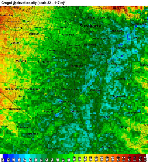
Below is the Elevation map of Grogol, which displays elevation range with different colors. Scale of the first map is from 82 to 117 m (269 to 384 ft) with average elevation of 96.2 meters (=316 ft) [note 1]
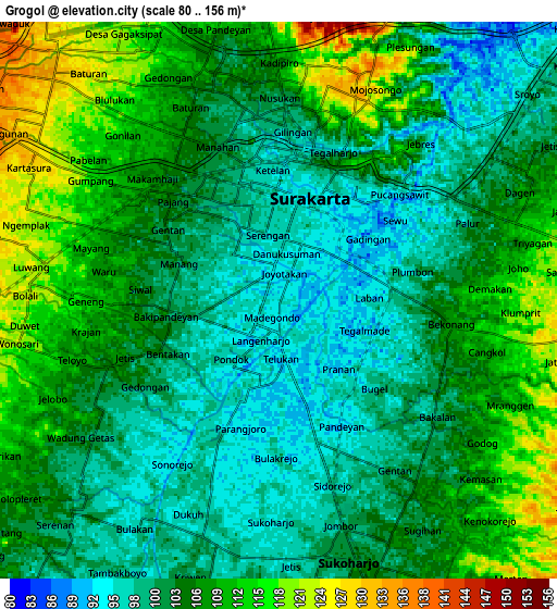
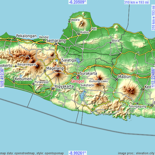
These maps also provides idea of topography and contour of this city, they are displayed at different zoom levels. More info about maps, scale and edge coordinates you can find below images.
| \ | Map #1 | Map #2 | Topo.Map |
| Scale [m] | 82..117 m | 80..156 m | × |
| Scale [ft] | 269..384 ft | 262..512 ft | × |
| Average | 96.2 m = 316 ft | 104.8 m = 344 ft | × |
| Width | 9.69 km = 6 mi | 19.37 km = 12 mi | 309.9 km = 192.6 mi |
| Height | 9.69 km = 6 mi | 19.37 km = 12 mi | 310 km = 192.6 mi |
| ↑Max Latitude | -7.557549° | -7.513983° | -6.20509° |
| Latitude at center | -7.60111° | -7.60111° | -7.60111° |
| ↓Min Latitude | -7.644667° | -7.688219° | -8.99261° |
| ← Min Longitude | 110.774665° | 110.730719° | 109.41236° |
| Longitude center | 110.81861° | 110.81861° | 110.81861° |
| →Max Longitude | 110.862555° | 110.906501° | 112.22486° |
Nearby cities:
Cities around Grogol sort by population:
• Surakarta elevation 100 m
5.2 km,  16°
16°
• Kartasura 134 m
10.5 km,  301°
301°
• Baki 104 m
4 km,  251°
251°
• Gatak 144 m
12.6 km,  275°
275°
• Jaten 113 m
9.1 km,  73°
73°
• Selogiri 117 m
20.9 km,  165°
165°
• Ceper 130 m
17.4 km,  242°
242°
• Colomadu 128 m
10.7 km,  314°
314°
• Delanggu 153 m
15 km,  263°
263°
• Ngemplak 143 m
12.6 km, 296°
• Karanganyar 157 m
13.9 km,  88°
88°
• Sukoharjo 103 m
8.2 km,  164°
164°
Multilingual:
 En español:
Grogol elevación 93 m.
 En France:
Grogol élévation 93 m.


Sources and notes:
- [note 1] Map square and city borders are not equal. Map elevation data is calculated only from area inside that square.
- [src 1] Elevation data from geonames database provided with same terms of usage.
- [src 2] The elevation map of Grogol is generated using elevation data from NASA's 3 arcsec (90m) resolution SRTM data.
- [src 3] Base (background) map © OpenStreetMap contributors tiles are generated by Geofabrik and OpenTopoMap.
Copyright & License:
This Grogol Elevation Map is licensed under CC BY-SA. You may reuse any part from this page, if you give a proper credit by linking to this URL:
 More info on terms of use page.