Ponorogo elevation
Ponorogo (East Java), Indonesia elevation is 103 meters and Ponorogo elevation in feet is 338 ft above sea level [src 1]. Ponorogo is a seat of a second-order administrative division (feature code) with elevation that is 88 meters (289 ft) smaller than average city elevation in Indonesia.
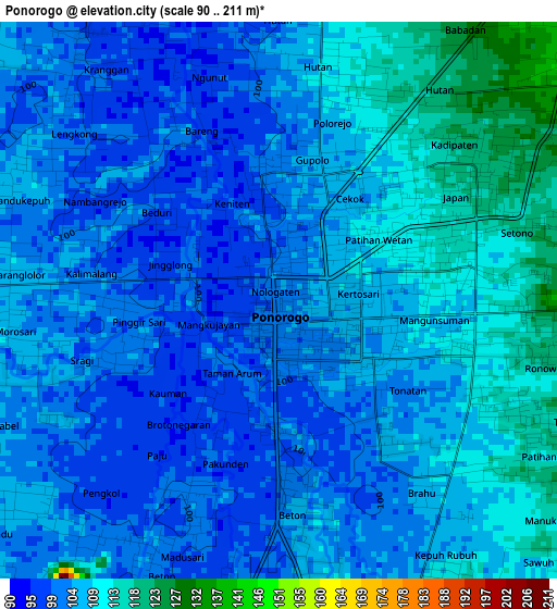
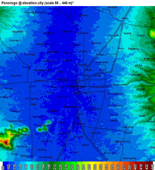
Below is the Elevation map of Ponorogo, which displays elevation range with different colors. Scale of the first map is from 90 to 211 m (295 to 692 ft) with average elevation of 105.1 meters (=345 ft) [note 1]
These maps also provides idea of topography and contour of this city, they are displayed at different zoom levels. More info about maps, scale and edge coordinates you can find below images.
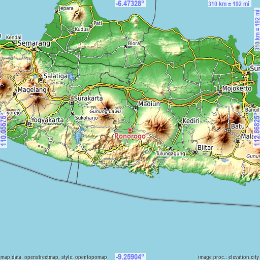
| \ | Map #1 | Map #2 | Topo.Map |
| Scale [m] | 90..211 m | 88..446 m | × |
| Scale [ft] | 295..692 ft | 289..1463 ft | × |
| Average | 105.1 m = 345 ft | 124.5 m = 408 ft | × |
| Width | 9.68 km = 6 mi | 19.36 km = 12 mi | 309.7 km = 192.4 mi |
| Height | 9.68 km = 6 mi | 19.36 km = 12 mi | 309.8 km = 192.5 mi |
| ↑Max Latitude | -7.824966° | -7.781428° | -6.47328° |
| Latitude at center | -7.8685° | -7.8685° | -7.8685° |
| ↓Min Latitude | -7.912029° | -7.955554° | -9.25904° |
| ← Min Longitude | 111.418055° | 111.374109° | 110.05575° |
| Longitude center | 111.462° | 111.462° | 111.462° |
| →Max Longitude | 111.505945° | 111.549891° | 112.86825° |
Nearby cities:
Cities around Ponorogo sort by population:
• Madiun elevation 69 m
27.4 km,  14°
14°
• Jatiroto 265 m
38.1 km,  267°
267°
• Trenggalek 113 m
35.5 km,  130°
130°
• Dongko 535 m
37.6 km,  160°
160°
• Sumbergedong 114 m
33.9 km, 127°
• Karangan 129 m
32.6 km,  138°
138°
• Pule 726 m
30.4 km, 158°
• Gondang 124 m
29.1 km, 132°
• Magetan 356 m
27.6 km,  328°
328°
• Ngrayun 528 m
22.7 km,  183°
183°
• Dawang 171 m
19.3 km,  195°
195°
• Bungkal 131 m
15.5 km, 183°
Multilingual:
 En español:
Ponorogo elevación 103 m.
 En France:
Ponorogo élévation 103 m.
 Auf Deutsch:
Ponorogo höhe über dem Meeresspiegel ist 103 m.

Sources and notes:
- [note 1] Map square and city borders are not equal. Map elevation data is calculated only from area inside that square.
- [src 1] Elevation data from geonames database provided with same terms of usage.
- [src 2] The elevation map of Ponorogo is generated using elevation data from NASA's 3 arcsec (90m) resolution SRTM data.
- [src 3] Base (background) map © OpenStreetMap contributors tiles are generated by Geofabrik and OpenTopoMap.
Copyright & License:
This Ponorogo Elevation Map is licensed under CC BY-SA. You may reuse any part from this page, if you give a proper credit by linking to this URL:
 More info on terms of use page.