Kotabumi elevation
Kotabumi (Lampung), Indonesia elevation is 37 meters and Kotabumi elevation in feet is 121 ft above sea level [src 1]. Kotabumi is a seat of a second-order administrative division (feature code) with elevation that is 154 meters (505 ft) smaller than average city elevation in Indonesia.
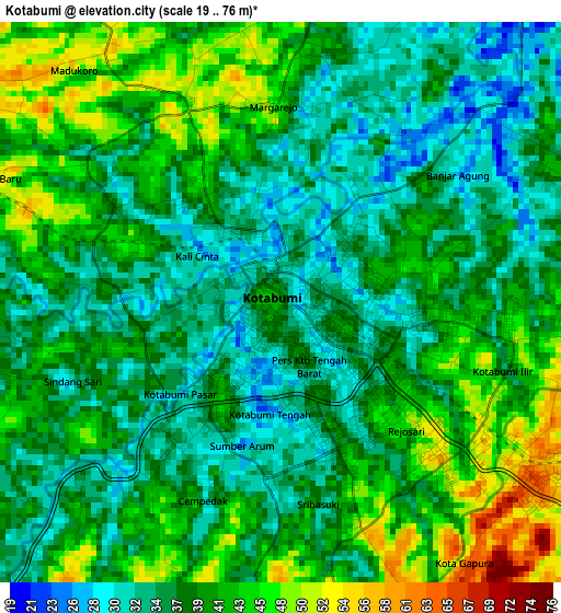
Below is the Elevation map of Kotabumi, which displays elevation range with different colors. Scale of the first map is from 19 to 76 m (62 to 249 ft) with average elevation of 38.6 meters (=127 ft) [note 1]
These maps also provides idea of topography and contour of this city, they are displayed at different zoom levels. More info about maps, scale and edge coordinates you can find below images.

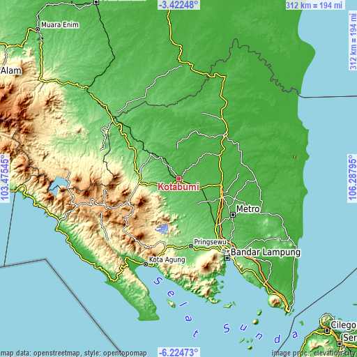
| \ | Map #1 | Map #2 | Topo.Map |
| Scale [m] | 19..76 m | 16..84 m | × |
| Scale [ft] | 62..249 ft | 52..276 ft | × |
| Average | 38.6 m = 127 ft | 46.9 m = 154 ft | × |
| Width | 9.74 km = 6.1 mi | 19.48 km = 12.1 mi | 311.6 km = 193.6 mi |
| Height | 9.74 km = 6.1 mi | 19.48 km = 12.1 mi | 311.6 km = 193.6 mi |
| ↑Max Latitude | -4.781259° | -4.737465° | -3.42248° |
| Latitude at center | -4.82505° | -4.82505° | -4.82505° |
| ↓Min Latitude | -4.868838° | -4.912623° | -6.22473° |
| ← Min Longitude | 104.837755° | 104.793809° | 103.47545° |
| Longitude center | 104.8817° | 104.8817° | 104.8817° |
| →Max Longitude | 104.925645° | 104.969591° | 106.28795° |
Nearby cities:
Cities around Kotabumi sort by population:
• Terbanggi Besar elevation 29 m
37.8 km,  99°
99°
• Kalirejo 128 m
45.4 km,  168°
168°
• Panaragan 14 m
44.5 km,  29°
29°
• Bara Datu 179 m
43.6 km,  281°
281°
• Gunung Sugih 39 m
40.4 km,  114°
114°
• Umbulan Kapiak 237 m
39.1 km,  268°
268°
• Bangunrejo 89 m
39.1 km,  153°
153°
• Bukitkemuning 296 m
34.3 km,  263°
263°
• Negararatu 49 m
24.8 km,  319°
319°
• Oganlima 121 m
20.3 km, 256°
• Pakuan Agung 23 m
20 km, 26°
• Ketapang 48 m
15.4 km, 323°
Multilingual:
 En español:
Kotabumi elevación 37 m.
 En France:
Kotabumi élévation 37 m.


Sources and notes:
- [note 1] Map square and city borders are not equal. Map elevation data is calculated only from area inside that square.
- [src 1] Elevation data from geonames database provided with same terms of usage.
- [src 2] The elevation map of Kotabumi is generated using elevation data from NASA's 3 arcsec (90m) resolution SRTM data.
- [src 3] Base (background) map © OpenStreetMap contributors tiles are generated by Geofabrik and OpenTopoMap.
Copyright & License:
This Kotabumi Elevation Map is licensed under CC BY-SA. You may reuse any part from this page, if you give a proper credit by linking to this URL:
 More info on terms of use page.