Terbanggi Besar elevation
Terbanggi Besar (Lampung), Indonesia elevation is 29 meters and Terbanggi Besar elevation in feet is 95 ft above sea level [src 1]. Terbanggi Besar is a seat of a third-order administrative division (feature code) with elevation that is 162 meters (531 ft) smaller than average city elevation in Indonesia.
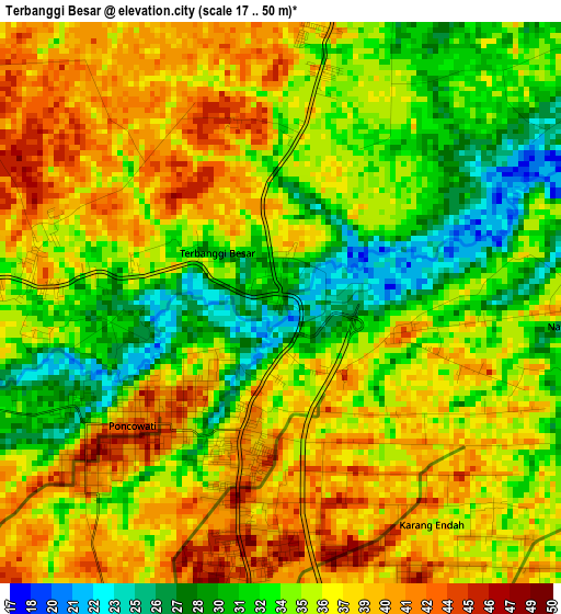
Below is the Elevation map of Terbanggi Besar, which displays elevation range with different colors. Scale of the first map is from 17 to 50 m (56 to 164 ft) with average elevation of 35.4 meters (=116 ft) [note 1]
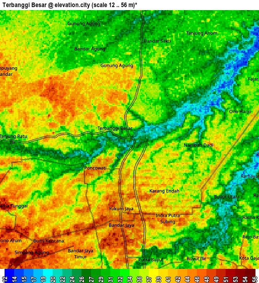
These maps also provides idea of topography and contour of this city, they are displayed at different zoom levels. More info about maps, scale and edge coordinates you can find below images.
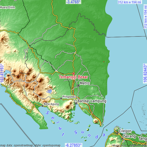
| \ | Map #1 | Map #2 | Topo.Map |
| Scale [m] | 17..50 m | 12..56 m | × |
| Scale [ft] | 56..164 ft | 39..184 ft | × |
| Average | 35.4 m = 116 ft | 35.2 m = 115 ft | × |
| Width | 9.74 km = 6.1 mi | 19.47 km = 12.1 mi | 311.6 km = 193.6 mi |
| Height | 9.74 km = 6.1 mi | 19.47 km = 12.1 mi | 311.6 km = 193.6 mi |
| ↑Max Latitude | -4.835192° | -4.791402° | -3.4765° |
| Latitude at center | -4.87898° | -4.87898° | -4.87898° |
| ↓Min Latitude | -4.922765° | -4.966546° | -6.27853° |
| ← Min Longitude | 105.174235° | 105.130289° | 103.81193° |
| Longitude center | 105.21818° | 105.21818° | 105.21818° |
| →Max Longitude | 105.262125° | 105.306071° | 106.62443° |
Nearby cities:
Cities around Terbanggi Besar sort by population:
• Metro elevation 62 m
27.8 km,  159°
159°
• Kotabumi 37 m
37.8 km,  279°
279°
• Panaragan 14 m
47.1 km,  341°
341°
• Menggala 27 m
45.5 km,  4°
4°
• Sukadana 19 m
42 km,  119°
119°
• Sekampung 51 m
37.2 km,  139°
139°
• Pakuan Agung 23 m
37 km,  310°
310°
• Bangunrejo 89 m
35.3 km,  214°
214°
• Batanghari 53 m
33.9 km,  149°
149°
• Pekalongan 49 m
27.5 km, 145°
• Punggur 49 m
19.2 km, 160°
• Gunung Sugih 39 m
10.7 km,  182°
182°
Multilingual:
 En español:
Terbanggi Besar elevación 29 m.
 En France:
Terbanggi Besar élévation 29 m.
 Auf Deutsch:
Terbanggi Besar höhe über dem Meeresspiegel ist 29 m.

Sources and notes:
- [note 1] Map square and city borders are not equal. Map elevation data is calculated only from area inside that square.
- [src 1] Elevation data from geonames database provided with same terms of usage.
- [src 2] The elevation map of Terbanggi Besar is generated using elevation data from NASA's 3 arcsec (90m) resolution SRTM data.
- [src 3] Base (background) map © OpenStreetMap contributors tiles are generated by Geofabrik and OpenTopoMap.
Copyright & License:
This Terbanggi Besar Elevation Map is licensed under CC BY-SA. You may reuse any part from this page, if you give a proper credit by linking to this URL:
 More info on terms of use page.