Metro elevation
Metro (Lampung), Indonesia elevation is 62 meters and Metro elevation in feet is 203 ft above sea level [src 1]. Metro is a populated place (feature code) with elevation that is 129 meters (423 ft) smaller than average city elevation in Indonesia.
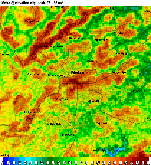
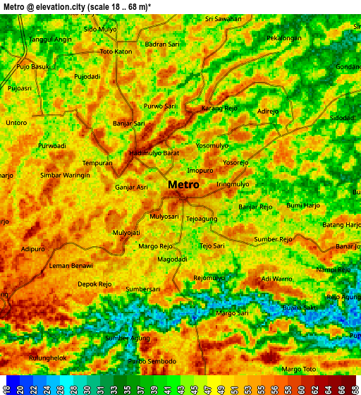
Below is the Elevation map of Metro, which displays elevation range with different colors. Scale of the first map is from 27 to 65 m (89 to 213 ft) with average elevation of 49.5 meters (=162 ft) [note 1]
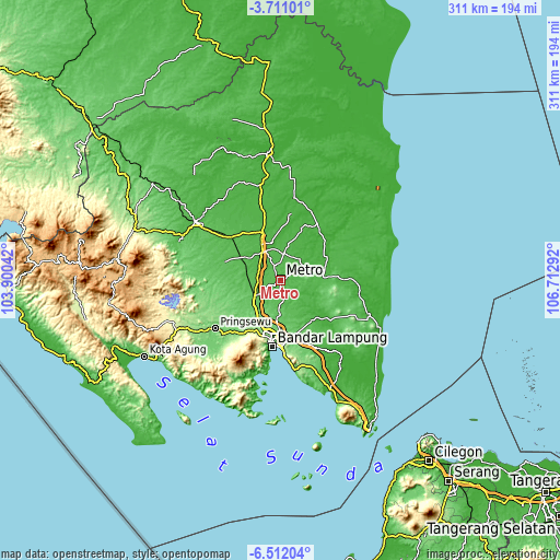
These maps also provides idea of topography and contour of this city, they are displayed at different zoom levels. More info about maps, scale and edge coordinates you can find below images.
| \ | Map #1 | Map #2 | Topo.Map |
| Scale [m] | 27..65 m | 18..68 m | × |
| Scale [ft] | 89..213 ft | 59..223 ft | × |
| Average | 49.5 m = 162 ft | 46.9 m = 154 ft | × |
| Width | 9.73 km = 6 mi | 19.47 km = 12.1 mi | 311.4 km = 193.5 mi |
| Height | 9.73 km = 6 mi | 19.47 km = 12.1 mi | 311.5 km = 193.6 mi |
| ↑Max Latitude | -5.069288° | -5.025513° | -3.71101° |
| Latitude at center | -5.11306° | -5.11306° | -5.11306° |
| ↓Min Latitude | -5.156829° | -5.200595° | -6.51204° |
| ← Min Longitude | 105.262725° | 105.218779° | 103.90042° |
| Longitude center | 105.30667° | 105.30667° | 105.30667° |
| →Max Longitude | 105.350615° | 105.394561° | 106.71292° |
Nearby cities:
Cities around Metro sort by population:
• Bandar Lampung elevation 95 m
35.5 km,  188°
188°
• Terbanggi Besar 29 m
27.8 km,  339°
339°
• Gedong Tataan 120 m
38 km,  217°
217°
• Kedaton 117 m
30.5 km, 189°
• Bangunrejo 89 m
30 km,  264°
264°
• Sukadana 19 m
27.3 km,  78°
78°
• Natar 109 m
25.2 km,  210°
210°
• Gunung Sugih 39 m
18.4 km,  326°
326°
• Sekampung 51 m
14.5 km,  98°
98°
• Punggur 49 m
8.6 km, 337°
• Batanghari 53 m
8.2 km,  112°
112°
• Pekalongan 49 m
6.7 km,  59°
59°
Multilingual:
 En español:
Metro elevación 62 m.
 En France:
Metro élévation 62 m.


Sources and notes:
- [note 1] Map square and city borders are not equal. Map elevation data is calculated only from area inside that square.
- [src 1] Elevation data from geonames database provided with same terms of usage.
- [src 2] The elevation map of Metro is generated using elevation data from NASA's 3 arcsec (90m) resolution SRTM data.
- [src 3] Base (background) map © OpenStreetMap contributors tiles are generated by Geofabrik and OpenTopoMap.
Copyright & License:
This Metro Elevation Map is licensed under CC BY-SA. You may reuse any part from this page, if you give a proper credit by linking to this URL:
 More info on terms of use page.