Bandar Lampung elevation
Bandar Lampung (Lampung), Indonesia elevation is 95 meters and Bandar Lampung elevation in feet is 312 ft above sea level [src 1]. Bandar Lampung is a seat of a first-order administrative division (feature code) with elevation that is 96 meters (315 ft) smaller than average city elevation in Indonesia.
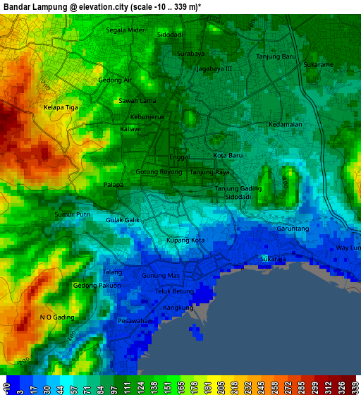
Below is the Elevation map of Bandar Lampung, which displays elevation range with different colors. Scale of the first map is from -10 to 339 m (-33 to 1112 ft) with average elevation of 109.7 meters (=360 ft) [note 1]
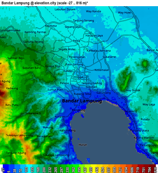
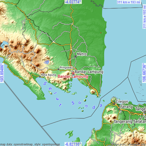
These maps also provides idea of topography and contour of this city, they are displayed at different zoom levels. More info about maps, scale and edge coordinates you can find below images.
| \ | Map #1 | Map #2 | Topo.Map |
| Scale [m] | -10..339 m | -27..816 m | × |
| Scale [ft] | -33..1112 ft | -89..2677 ft | × |
| Average | 109.7 m = 360 ft | 171.9 m = 564 ft | × |
| Width | 9.73 km = 6 mi | 19.46 km = 12.1 mi | 311.3 km = 193.4 mi |
| Height | 9.73 km = 6 mi | 19.46 km = 12.1 mi | 311.3 km = 193.4 mi |
| ↑Max Latitude | -5.38542° | -5.341667° | -4.02774° |
| Latitude at center | -5.42917° | -5.42917° | -5.42917° |
| ↓Min Latitude | -5.472917° | -5.51666° | -6.82735° |
| ← Min Longitude | 105.217165° | 105.173219° | 103.85486° |
| Longitude center | 105.26111° | 105.26111° | 105.26111° |
| →Max Longitude | 105.305055° | 105.349001° | 106.66736° |
Nearby cities:
Cities around Bandar Lampung sort by population:
• Metro elevation 62 m
35.5 km,  8°
8°
• Batanghari 53 m
34.4 km,  21°
21°
• Sukoharjo Satu 134 m
33.9 km,  294°
294°
• Sidorejo 38 m
33.8 km,  120°
120°
• Pringsewu 110 m
32.7 km,  283°
283°
• Kedondong 121 m
29 km,  262°
262°
• Padangcermin 12 m
23.4 km,  215°
215°
• Gadingrejo 118 m
23 km, 285°
• Gedong Tataan 120 m
19 km, 285°
• Natar 109 m
15.4 km,  330°
330°
• Panjang 6 m
8.3 km,  128°
128°
• Kedaton 117 m
5.1 km,  358°
358°
Multilingual:
 En español:
Bandar Lampung elevación 95 m.
 En France:
Bandar Lampung élévation 95 m.
 Auf Deutsch:
Bandar Lampung höhe über dem Meeresspiegel ist 95 m.

Sources and notes:
- [note 1] Map square and city borders are not equal. Map elevation data is calculated only from area inside that square.
- [src 1] Elevation data from geonames database provided with same terms of usage.
- [src 2] The elevation map of Bandar Lampung is generated using elevation data from NASA's 3 arcsec (90m) resolution SRTM data.
- [src 3] Base (background) map © OpenStreetMap contributors tiles are generated by Geofabrik and OpenTopoMap.
Copyright & License:
This Bandar Lampung Elevation Map is licensed under CC BY-SA. You may reuse any part from this page, if you give a proper credit by linking to this URL:
 More info on terms of use page.