Pekalongan elevation
Pekalongan (Central Java), Indonesia elevation is 10 meters and Pekalongan elevation in feet is 33 ft above sea level [src 1]. Pekalongan is a populated place (feature code) with elevation that is 181 meters (594 ft) smaller than average city elevation in Indonesia.
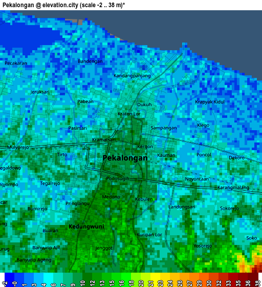
Below is the Elevation map of Pekalongan, which displays elevation range with different colors. Scale of the first map is from -2 to 38 m (-7 to 125 ft) with average elevation of 6.6 meters (=22 ft) [note 1]
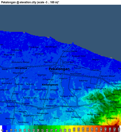
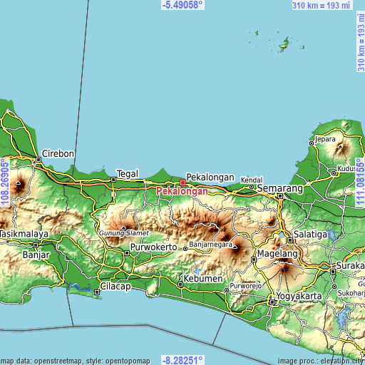
These maps also provides idea of topography and contour of this city, they are displayed at different zoom levels. More info about maps, scale and edge coordinates you can find below images.
| \ | Map #1 | Map #2 | Topo.Map |
| Scale [m] | -2..38 m | -3..169 m | × |
| Scale [ft] | -7..125 ft | -10..554 ft | × |
| Average | 6.6 m = 22 ft | 15.1 m = 50 ft | × |
| Width | 9.7 km = 6 mi | 19.4 km = 12.1 mi | 310.4 km = 192.9 mi |
| Height | 9.7 km = 6 mi | 19.4 km = 12.1 mi | 310.5 km = 192.9 mi |
| ↑Max Latitude | -6.84497° | -6.801336° | -5.49058° |
| Latitude at center | -6.8886° | -6.8886° | -6.8886° |
| ↓Min Latitude | -6.932226° | -6.975848° | -8.28251° |
| ← Min Longitude | 109.631355° | 109.587409° | 108.26905° |
| Longitude center | 109.6753° | 109.6753° | 109.6753° |
| →Max Longitude | 109.719245° | 109.763191° | 111.08155° |
Nearby cities:
Cities around Pekalongan sort by population:
• Pemalang elevation 19 m
32.3 km,  269°
269°
• Kedungwuni 17 m
9.6 km,  198°
198°
• Tarub 22 m
56.4 km,  264°
264°
• Weleri 17 m
44.2 km,  102°
102°
• Comal 13 m
15.6 km, 263°
• Wiradesa 10 m
6.2 km, 266°
• Buaran 21 m
22.7 km,  217°
217°
• Wonopringgo 45 m
12.4 km,  211°
211°
• Randudongkal 216 m
45.2 km,  238°
238°
• Banjarnegara 300 m
56.5 km,  177°
177°
• Kajen 36 m
19.3 km, 214°
• Batang 10 m
6.4 km,  109°
109°
Multilingual:
 En español:
Pekalongan elevación 10 m.
 En France:
Pekalongan élévation 10 m.
 Auf Deutsch:
Pekalongan höhe über dem Meeresspiegel ist 10 m.

Sources and notes:
- [note 1] Map square and city borders are not equal. Map elevation data is calculated only from area inside that square.
- [src 1] Elevation data from geonames database provided with same terms of usage.
- [src 2] The elevation map of Pekalongan is generated using elevation data from NASA's 3 arcsec (90m) resolution SRTM data.
- [src 3] Base (background) map © OpenStreetMap contributors tiles are generated by Geofabrik and OpenTopoMap.
Copyright & License:
This Pekalongan Elevation Map is licensed under CC BY-SA. You may reuse any part from this page, if you give a proper credit by linking to this URL:
 More info on terms of use page.