Sungai Penuh elevation
Sungai Penuh (Jambi), Indonesia elevation is 811 meters and Sungai Penuh elevation in feet is 2661 ft above sea level [src 1]. Sungai Penuh is a populated place (feature code) with elevation that is 620 meters (2034 ft) bigger than average city elevation in Indonesia.
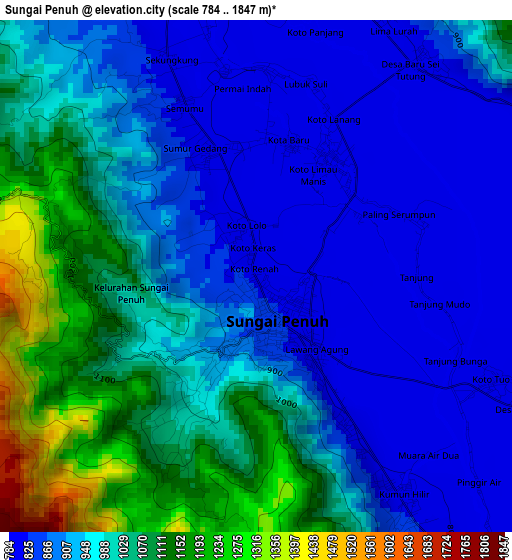
Below is the Elevation map of Sungai Penuh, which displays elevation range with different colors. Scale of the first map is from 784 to 1847 m (2572 to 6060 ft) with average elevation of 958.3 meters (=3144 ft) [note 1]
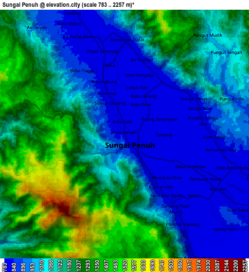
These maps also provides idea of topography and contour of this city, they are displayed at different zoom levels. More info about maps, scale and edge coordinates you can find below images.
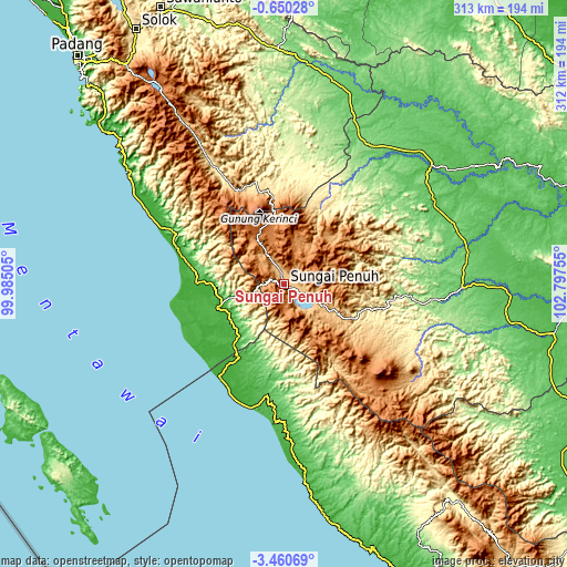
| \ | Map #1 | Map #2 | Topo.Map |
| Scale [m] | 784..1847 m | 783..2257 m | × |
| Scale [ft] | 2572..6060 ft | 2569..7405 ft | × |
| Average | 958.3 m = 3144 ft | 1100.6 m = 3611 ft | × |
| Width | 9.77 km = 6.1 mi | 19.53 km = 12.1 mi | 312.5 km = 194.2 mi |
| Height | 9.77 km = 6.1 mi | 19.53 km = 12.1 mi | 312.5 km = 194.2 mi |
| ↑Max Latitude | -2.012182° | -1.968264° | -0.65028° |
| Latitude at center | -2.0561° | -2.0561° | -2.0561° |
| ↓Min Latitude | -2.100016° | -2.143932° | -3.46069° |
| ← Min Longitude | 101.347355° | 101.303409° | 99.98505° |
| Longitude center | 101.3913° | 101.3913° | 101.3913° |
| →Max Longitude | 101.435245° | 101.479191° | 102.79755° |
Nearby cities:
Cities around Sungai Penuh sort by population:
• Rantauambacang elevation 98 m
93.9 km,  38°
38°
• Jangkat 683 m
89.1 km,  124°
124°
• Kambang 6 m
84.9 km,  298°
298°
• Muarasiau 224 m
82.3 km,  107°
107°
• Muaralabuh 439 m
77.7 km,  328°
328°
• Mandarahan 61 m
68.8 km,  294°
294°
• Mukomuko 9 m
64.9 km,  208°
208°
• Lubukgadang 428 m
60.5 km,  347°
347°
• Padang Aro 456 m
60.5 km, 346°
• Siulakderasmudik 1160 m
24.4 km,  312°
312°
• Siulak 862 m
13.7 km, 332°
• Semurup 808 m
7.6 km,  340°
340°
Multilingual:
 En español:
Sungai Penuh elevación 811 m.
 En France:
Sungai Penuh élévation 811 m.
 Auf Deutsch:
Sungai Penuh höhe über dem Meeresspiegel ist 811 m.

Sources and notes:
- [note 1] Map square and city borders are not equal. Map elevation data is calculated only from area inside that square.
- [src 1] Elevation data from geonames database provided with same terms of usage.
- [src 2] The elevation map of Sungai Penuh is generated using elevation data from NASA's 3 arcsec (90m) resolution SRTM data.
- [src 3] Base (background) map © OpenStreetMap contributors tiles are generated by Geofabrik and OpenTopoMap.
Copyright & License:
This Sungai Penuh Elevation Map is licensed under CC BY-SA. You may reuse any part from this page, if you give a proper credit by linking to this URL:
 More info on terms of use page.