Rantauambacang elevation
Rantauambacang (Jambi), Indonesia elevation is 98 meters and Rantauambacang elevation in feet is 322 ft above sea level [src 1]. Rantauambacang is a seat of a third-order administrative division (feature code) with elevation that is 93 meters (305 ft) smaller than average city elevation in Indonesia.
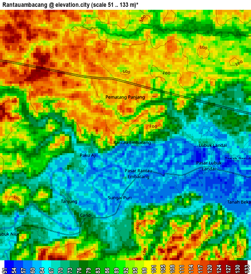
Below is the Elevation map of Rantauambacang, which displays elevation range with different colors. Scale of the first map is from 51 to 133 m (167 to 436 ft) with average elevation of 87.2 meters (=286 ft) [note 1]
These maps also provides idea of topography and contour of this city, they are displayed at different zoom levels. More info about maps, scale and edge coordinates you can find below images.
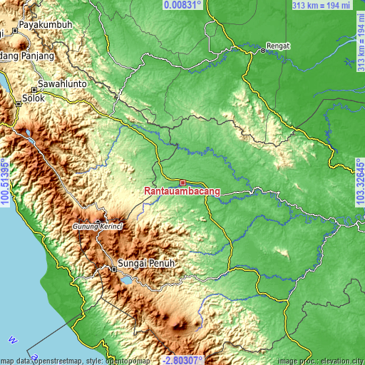
| \ | Map #1 | Topo.Map |
| Scale [m] | 51..133 m | × |
| Scale [ft] | 167..436 ft | × |
| Average | 87.2 m = 286 ft | × |
| Width | 9.77 km = 6.1 mi | 312.6 km = 194.2 mi |
| Height | 9.77 km = 6.1 mi | 312.6 km = 194.2 mi |
| ↑Max Latitude | -1.353867° | 0.00831° |
| Latitude at center | -1.3978° | -1.3978° |
| ↓Min Latitude | -1.441732° | -2.80307° |
| ← Min Longitude | 101.876255° | 100.51395° |
| Longitude center | 101.9202° | 101.9202° |
| →Max Longitude | 101.964145° | 103.32645° |
Nearby cities:
Cities around Rantauambacang sort by population:
• Sungai Penuh elevation 811 m
93.9 km,  218°
218°
• Semurup 808 m
90.1 km, 222°
• Siulak 862 m
89.3 km,  226°
226°
• Bangko 65 m
84.6 km,  153°
153°
• Padang Aro 456 m
74.4 km,  258°
258°
• Lubukgadang 428 m
73.3 km, 258°
• Pulau Punjung 114 m
67.5 km,  316°
316°
• Rantaupanjang 70 m
65.8 km,  139°
139°
• Muara Tebo 46 m
58.8 km,  98°
98°
• Pulautemiang 47 m
40.6 km,  61°
61°
• Kotabaru 84 m
37.4 km,  331°
331°
• Muara Bungo 53 m
24 km,  115°
115°
Multilingual:
 En español:
Rantauambacang elevación 98 m.
 En France:
Rantauambacang élévation 98 m.
 Auf Deutsch:
Rantauambacang höhe über dem Meeresspiegel ist 98 m.

Sources and notes:
- [note 1] Map square and city borders are not equal. Map elevation data is calculated only from area inside that square.
- [src 1] Elevation data from geonames database provided with same terms of usage.
- [src 2] The elevation map of Rantauambacang is generated using elevation data from NASA's 3 arcsec (90m) resolution SRTM data.
- [src 3] Base (background) map © OpenStreetMap contributors tiles are generated by Geofabrik and OpenTopoMap.
Copyright & License:
This Rantauambacang Elevation Map is licensed under CC BY-SA. You may reuse any part from this page, if you give a proper credit by linking to this URL:
 More info on terms of use page.