Tais elevation
Tais (Bengkulu), Indonesia elevation is 70 meters and Tais elevation in feet is 230 ft above sea level [src 1]. Tais is a seat of a second-order administrative division (feature code) with elevation that is 121 meters (397 ft) smaller than average city elevation in Indonesia.
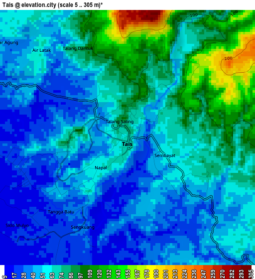
Below is the Elevation map of Tais, which displays elevation range with different colors. Scale of the first map is from 5 to 305 m (16 to 1001 ft) with average elevation of 62.5 meters (=205 ft) [note 1]
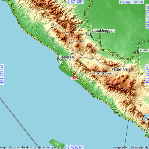
These maps also provides idea of topography and contour of this city, they are displayed at different zoom levels. More info about maps, scale and edge coordinates you can find below images.
| \ | Map #1 | Topo.Map |
| Scale [m] | 5..305 m | × |
| Scale [ft] | 16..1001 ft | × |
| Average | 62.5 m = 205 ft | × |
| Width | 9.75 km = 6.1 mi | 311.9 km = 193.8 mi |
| Height | 9.75 km = 6.1 mi | 311.9 km = 193.8 mi |
| ↑Max Latitude | -4.031595° | -2.67165° |
| Latitude at center | -4.07543° | -4.07543° |
| ↓Min Latitude | -4.119263° | -5.47676° |
| ← Min Longitude | 102.533445° | 101.17114° |
| Longitude center | 102.57739° | 102.57739° |
| →Max Longitude | 102.621335° | 103.98364° |
Nearby cities:
Cities around Tais sort by population:
• Bengkulu elevation 19 m
46.2 km,  311°
311°
• Pagar Alam 720 m
74.5 km,  85°
85°
• Curup 630 m
67.6 km,  354°
354°
• Tebing Tinggi 123 m
77.8 km,  45°
45°
• Muarapinang 440 m
58.4 km,  64°
64°
• Manna 31 m
56.5 km,  140°
140°
• Tanjungsakti 546 m
55.4 km,  100°
100°
• Masat 127 m
53.8 km,  129°
129°
• Kepahiang 498 m
47.8 km,  359°
359°
• Padangtepung 276 m
43.1 km,  33°
33°
• Karang Tinggi 43 m
40.1 km,  334°
334°
• Masmambang 45 m
16.8 km, 125°
Multilingual:
 En español:
Tais elevación 70 m.
 En France:
Tais élévation 70 m.


Sources and notes:
- [note 1] Map square and city borders are not equal. Map elevation data is calculated only from area inside that square.
- [src 1] Elevation data from geonames database provided with same terms of usage.
- [src 2] The elevation map of Tais is generated using elevation data from NASA's 3 arcsec (90m) resolution SRTM data.
- [src 3] Base (background) map © OpenStreetMap contributors tiles are generated by Geofabrik and OpenTopoMap.
Copyright & License:
This Tais Elevation Map is licensed under CC BY-SA. You may reuse any part from this page, if you give a proper credit by linking to this URL:
 More info on terms of use page.