Curup elevation
Curup (Bengkulu), Indonesia elevation is 630 meters and Curup elevation in feet is 2067 ft above sea level [src 1]. Curup is a seat of a second-order administrative division (feature code) with elevation that is 439 meters (1440 ft) bigger than average city elevation in Indonesia.
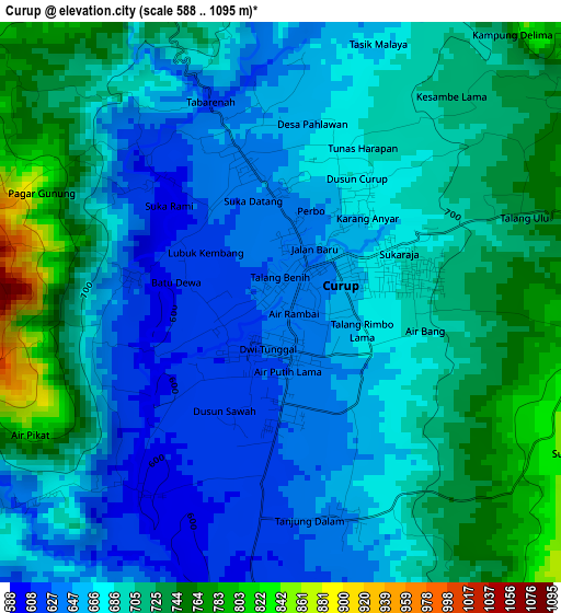
Below is the Elevation map of Curup, which displays elevation range with different colors. Scale of the first map is from 588 to 1095 m (1929 to 3593 ft) with average elevation of 687.7 meters (=2256 ft) [note 1]
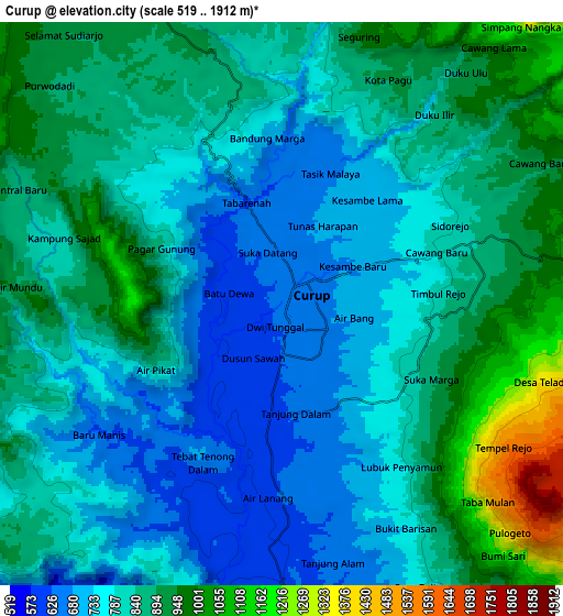
These maps also provides idea of topography and contour of this city, they are displayed at different zoom levels. More info about maps, scale and edge coordinates you can find below images.
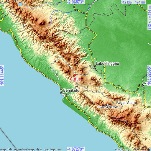
| \ | Map #1 | Map #2 | Topo.Map |
| Scale [m] | 588..1095 m | 519..1912 m | × |
| Scale [ft] | 1929..3593 ft | 1703..6273 ft | × |
| Average | 687.7 m = 2256 ft | 832.7 m = 2732 ft | × |
| Width | 9.75 km = 6.1 mi | 19.51 km = 12.1 mi | 312.1 km = 193.9 mi |
| Height | 9.75 km = 6.1 mi | 19.51 km = 12.1 mi | 312.1 km = 193.9 mi |
| ↑Max Latitude | -3.426434° | -3.382567° | -2.06573° |
| Latitude at center | -3.4703° | -3.4703° | -3.4703° |
| ↓Min Latitude | -3.514164° | -3.558025° | -4.87279° |
| ← Min Longitude | 102.476755° | 102.432809° | 101.11445° |
| Longitude center | 102.5207° | 102.5207° | 102.5207° |
| →Max Longitude | 102.564645° | 102.608591° | 103.92695° |
Nearby cities:
Cities around Curup sort by population:
• Bengkulu elevation 19 m
46.4 km,  217°
217°
• Lubuklinggau 140 m
42.6 km,  62°
62°
• Tebing Tinggi 123 m
63 km,  101°
101°
• Muara Beliti 66 m
62 km,  66°
66°
• Terawas 59 m
56.8 km,  35°
35°
• Tubei 335 m
52.8 km,  317°
317°
• Lais 28 m
52.7 km,  262°
262°
• Padangtepung 276 m
43.8 km,  136°
136°
• Argamakmur 157 m
37.2 km,  278°
278°
• Karang Tinggi 43 m
33 km,  199°
199°
• Padangulaktanding 255 m
32.7 km, 71°
• Kepahiang 498 m
20.3 km,  163°
163°
Multilingual:
 En español:
Curup elevación 630 m.
 En France:
Curup élévation 630 m.


Sources and notes:
- [note 1] Map square and city borders are not equal. Map elevation data is calculated only from area inside that square.
- [src 1] Elevation data from geonames database provided with same terms of usage.
- [src 2] The elevation map of Curup is generated using elevation data from NASA's 3 arcsec (90m) resolution SRTM data.
- [src 3] Base (background) map © OpenStreetMap contributors tiles are generated by Geofabrik and OpenTopoMap.
Copyright & License:
This Curup Elevation Map is licensed under CC BY-SA. You may reuse any part from this page, if you give a proper credit by linking to this URL:
 More info on terms of use page.