Lubuklinggau elevation
Lubuklinggau (South Sumatra, Kota Lubuklinggau), Indonesia elevation is 140 meters and Lubuklinggau elevation in feet is 459 ft above sea level [src 1]. Lubuklinggau is a seat of a second-order administrative division (feature code) with elevation that is 51 meters (167 ft) smaller than average city elevation in Indonesia.
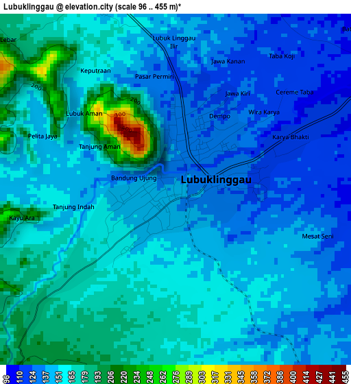
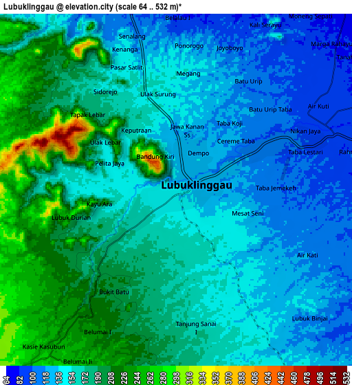
Below is the Elevation map of Lubuklinggau, which displays elevation range with different colors. Scale of the first map is from 96 to 455 m (315 to 1493 ft) with average elevation of 153.9 meters (=505 ft) [note 1]
These maps also provides idea of topography and contour of this city, they are displayed at different zoom levels. More info about maps, scale and edge coordinates you can find below images.
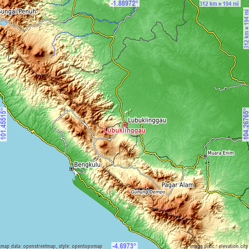
| \ | Map #1 | Map #2 | Topo.Map |
| Scale [m] | 96..455 m | 64..532 m | × |
| Scale [ft] | 315..1493 ft | 210..1745 ft | × |
| Average | 153.9 m = 505 ft | 164.3 m = 539 ft | × |
| Width | 9.76 km = 6.1 mi | 19.51 km = 12.1 mi | 312.2 km = 194 mi |
| Height | 9.76 km = 6.1 mi | 19.51 km = 12.1 mi | 312.2 km = 194 mi |
| ↑Max Latitude | -3.250626° | -3.206751° | -1.88972° |
| Latitude at center | -3.2945° | -3.2945° | -3.2945° |
| ↓Min Latitude | -3.338372° | -3.382241° | -4.6973° |
| ← Min Longitude | 102.817455° | 102.773509° | 101.45515° |
| Longitude center | 102.8614° | 102.8614° | 102.8614° |
| →Max Longitude | 102.905345° | 102.949291° | 104.26765° |
Nearby cities:
Cities around Lubuklinggau sort by population:
• Curup elevation 630 m
42.6 km,  242°
242°
• Bunga Mas 84 m
72.2 km,  128°
128°
• Karang Tinggi 43 m
70.3 km,  223°
223°
• Muaralakitan 24 m
69 km,  45°
45°
• Muarapinang 440 m
65.4 km,  160°
160°
• Muararupit 38 m
63.7 km,  4°
4°
• Padangtepung 276 m
51.6 km,  188°
188°
• Kepahiang 498 m
50.6 km, 219°
• Tebing Tinggi 123 m
40.1 km,  143°
143°
• Terawas 59 m
27.4 km,  349°
349°
• Muara Beliti 66 m
19.8 km,  75°
75°
• Padangulaktanding 255 m
11.3 km, 217°
Multilingual:
 En español:
Lubuklinggau elevación 140 m.
 En France:
Lubuklinggau élévation 140 m.
 Auf Deutsch:
Lubuklinggau höhe über dem Meeresspiegel ist 140 m.

Sources and notes:
- [note 1] Map square and city borders are not equal. Map elevation data is calculated only from area inside that square.
- [src 1] Elevation data from geonames database provided with same terms of usage.
- [src 2] The elevation map of Lubuklinggau is generated using elevation data from NASA's 3 arcsec (90m) resolution SRTM data.
- [src 3] Base (background) map © OpenStreetMap contributors tiles are generated by Geofabrik and OpenTopoMap.
Copyright & License:
This Lubuklinggau Elevation Map is licensed under CC BY-SA. You may reuse any part from this page, if you give a proper credit by linking to this URL:
 More info on terms of use page.