Ubud elevation
Ubud (Bali, Kabupaten Gianyar), Indonesia elevation is 210 meters and Ubud elevation in feet is 689 ft above sea level [src 1]. Ubud is a populated place (feature code) with elevation that is 19 meters (62 ft) bigger than average city elevation in Indonesia.
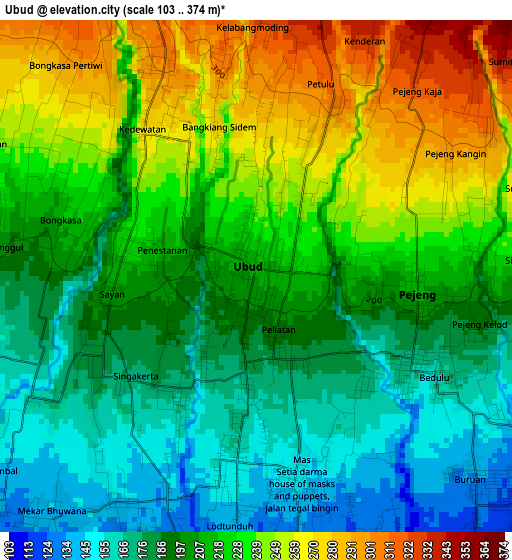
Below is the Elevation map of Ubud, which displays elevation range with different colors. Scale of the first map is from 103 to 374 m (338 to 1227 ft) with average elevation of 212.4 meters (=697 ft) [note 1]
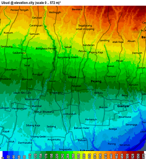
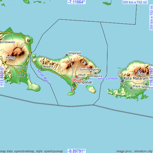
These maps also provides idea of topography and contour of this city, they are displayed at different zoom levels. More info about maps, scale and edge coordinates you can find below images.
| \ | Map #1 | Map #2 | Topo.Map |
| Scale [m] | 103..374 m | 0..572 m | × |
| Scale [ft] | 338..1227 ft | 0..1877 ft | × |
| Average | 212.4 m = 697 ft | 229.6 m = 753 ft | × |
| Width | 9.66 km = 6 mi | 19.33 km = 12 mi | 309.2 km = 192.1 mi |
| Height | 9.66 km = 6 mi | 19.33 km = 12 mi | 309.3 km = 192.2 mi |
| ↑Max Latitude | -8.466336° | -8.422867° | -7.11664° |
| Latitude at center | -8.5098° | -8.5098° | -8.5098° |
| ↓Min Latitude | -8.553259° | -8.596713° | -9.89791° |
| ← Min Longitude | 115.221455° | 115.177509° | 113.85915° |
| Longitude center | 115.2654° | 115.2654° | 115.2654° |
| →Max Longitude | 115.309345° | 115.353291° | 116.67165° |
Nearby cities:
Cities around Ubud sort by population:
• Tabanan elevation 126 m
15.8 km,  257°
257°
• Klungkung 95 m
15 km,  100°
100°
• Pohgending Kawan 362 m
15.8 km,  301°
301°
• Dajan Tangluk 37 m
15.4 km,  190°
190°
• Semarapura 97 m
15.3 km, 100°
• Tembuku 454 m
14.6 km,  63°
63°
• Sulahan 580 m
13.4 km,  42°
42°
• Bangli 423 m
11.6 km, 57°
• Basa 275 m
11.4 km,  290°
290°
• Mangupura 127 m
11.2 km,  250°
250°
• Tegalalang 439 m
8.3 km,  10°
10°
• Gianyar 123 m
7.8 km,  118°
118°
Multilingual:
 En español:
Ubud elevación 210 m.
 En France:
Ubud élévation 210 m.


Sources and notes:
- [note 1] Map square and city borders are not equal. Map elevation data is calculated only from area inside that square.
- [src 1] Elevation data from geonames database provided with same terms of usage.
- [src 2] The elevation map of Ubud is generated using elevation data from NASA's 3 arcsec (90m) resolution SRTM data.
- [src 3] Base (background) map © OpenStreetMap contributors tiles are generated by Geofabrik and OpenTopoMap.
Copyright & License:
This Ubud Elevation Map is licensed under CC BY-SA. You may reuse any part from this page, if you give a proper credit by linking to this URL:
 More info on terms of use page.