Semarapura elevation
Semarapura (Bali), Indonesia elevation is 97 meters and Semarapura elevation in feet is 318 ft above sea level [src 1]. Semarapura is a seat of a second-order administrative division (feature code) with elevation that is 94 meters (308 ft) smaller than average city elevation in Indonesia.
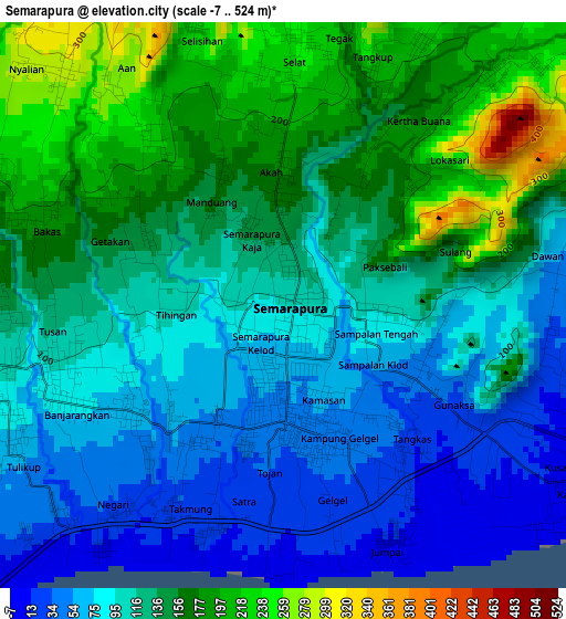
Below is the Elevation map of Semarapura, which displays elevation range with different colors. Scale of the first map is from -7 to 524 m (-23 to 1719 ft) with average elevation of 123.1 meters (=404 ft) [note 1]
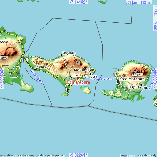
These maps also provides idea of topography and contour of this city, they are displayed at different zoom levels. More info about maps, scale and edge coordinates you can find below images.
| \ | Map #1 | Topo.Map |
| Scale [m] | -7..524 m | × |
| Scale [ft] | -23..1719 ft | × |
| Average | 123.1 m = 404 ft | × |
| Width | 9.66 km = 6 mi | 309.2 km = 192.1 mi |
| Height | 9.66 km = 6 mi | 309.3 km = 192.2 mi |
| ↑Max Latitude | -8.491139° | -7.14152° |
| Latitude at center | -8.5346° | -8.5346° |
| ↓Min Latitude | -8.578056° | -9.92261° |
| ← Min Longitude | 115.358255° | 113.99595° |
| Longitude center | 115.4022° | 115.4022° |
| →Max Longitude | 115.446145° | 116.80845° |
Nearby cities:
Cities around Semarapura sort by population:
• Ubud elevation 210 m
15.3 km,  280°
280°
• Klungkung 95 m
0.3 km,  300°
300°
• Banjar Wangsian 212 m
5 km,  27°
27°
• Bebandem 342 m
20.4 km,  58°
58°
• Tegalalang 439 m
17.4 km,  308°
308°
• Sulahan 580 m
14 km,  334°
334°
• Duda 519 m
13.9 km,  42°
42°
• Ulakan 32 m
12.8 km,  71°
71°
• Bangli 423 m
10.4 km, 329°
• Tembuku 454 m
9.4 km,  348°
348°
• Gianyar 123 m
8.3 km,  263°
263°
• Sidemen 280 m
7.3 km, 40°
Multilingual:
 En español:
Semarapura elevación 97 m.
 En France:
Semarapura élévation 97 m.
 Auf Deutsch:
Semarapura höhe über dem Meeresspiegel ist 97 m.

Sources and notes:
- [note 1] Map square and city borders are not equal. Map elevation data is calculated only from area inside that square.
- [src 1] Elevation data from geonames database provided with same terms of usage.
- [src 2] The elevation map of Semarapura is generated using elevation data from NASA's 3 arcsec (90m) resolution SRTM data.
- [src 3] Base (background) map © OpenStreetMap contributors tiles are generated by Geofabrik and OpenTopoMap.
Copyright & License:
This Semarapura Elevation Map is licensed under CC BY-SA. You may reuse any part from this page, if you give a proper credit by linking to this URL:
 More info on terms of use page.