Tabanan elevation
Tabanan (Bali), Indonesia elevation is 126 meters and Tabanan elevation in feet is 413 ft above sea level [src 1]. Tabanan is a seat of a second-order administrative division (feature code) with elevation that is 65 meters (213 ft) smaller than average city elevation in Indonesia.
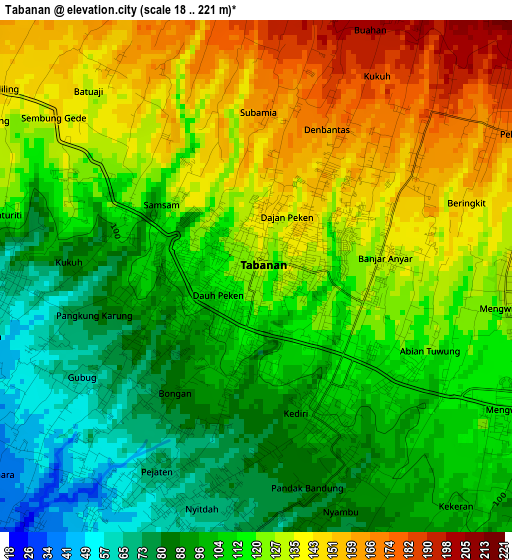
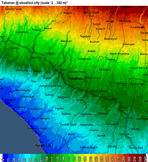
Below is the Elevation map of Tabanan, which displays elevation range with different colors. Scale of the first map is from 18 to 221 m (59 to 725 ft) with average elevation of 116.5 meters (=382 ft) [note 1]
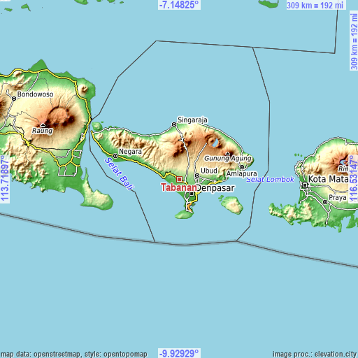
These maps also provides idea of topography and contour of this city, they are displayed at different zoom levels. More info about maps, scale and edge coordinates you can find below images.
| \ | Map #1 | Map #2 | Topo.Map |
| Scale [m] | 18..221 m | -2..342 m | × |
| Scale [ft] | 59..725 ft | -7..1122 ft | × |
| Average | 116.5 m = 382 ft | 134 m = 440 ft | × |
| Width | 9.66 km = 6 mi | 19.33 km = 12 mi | 309.2 km = 192.1 mi |
| Height | 9.66 km = 6 mi | 19.33 km = 12 mi | 309.3 km = 192.2 mi |
| ↑Max Latitude | -8.49784° | -8.454374° | -7.14825° |
| Latitude at center | -8.5413° | -8.5413° | -8.5413° |
| ↓Min Latitude | -8.584755° | -8.628206° | -9.92929° |
| ← Min Longitude | 115.081275° | 115.037329° | 113.71897° |
| Longitude center | 115.12522° | 115.12522° | 115.12522° |
| →Max Longitude | 115.169165° | 115.213111° | 116.53147° |
Nearby cities:
Cities around Tabanan sort by population:
• Denpasar elevation 33 m
15.7 km,  140°
140°
• Kuta 8 m
20.9 km,  165°
165°
• Ubud 210 m
15.8 km,  77°
77°
• Legian 8 m
18.8 km,  164°
164°
• Jabajero 7 m
21.4 km, 165°
• Karyadharma 7 m
20.8 km,  150°
150°
• Tegalalang 439 m
20.5 km,  55°
55°
• Dajan Tangluk 37 m
17.1 km,  132°
132°
• Pohgending Kawan 362 m
11.9 km,  9°
9°
• Basa 275 m
8.9 km,  32°
32°
• Mangupura 127 m
4.9 km,  93°
93°
• Banjar Mandung 137 m
4.5 km,  305°
305°
Multilingual:
 En español:
Tabanan elevación 126 m.
 En France:
Tabanan élévation 126 m.


Sources and notes:
- [note 1] Map square and city borders are not equal. Map elevation data is calculated only from area inside that square.
- [src 1] Elevation data from geonames database provided with same terms of usage.
- [src 2] The elevation map of Tabanan is generated using elevation data from NASA's 3 arcsec (90m) resolution SRTM data.
- [src 3] Base (background) map © OpenStreetMap contributors tiles are generated by Geofabrik and OpenTopoMap.
Copyright & License:
This Tabanan Elevation Map is licensed under CC BY-SA. You may reuse any part from this page, if you give a proper credit by linking to this URL:
 More info on terms of use page.