Kenyaran elevation
Kenyaran (Aceh), Indonesia elevation is 1170 meters and Kenyaran elevation in feet is 3839 ft above sea level [src 1]. Kenyaran is a seat of a third-order administrative division (feature code) with elevation that is 979 meters (3212 ft) bigger than average city elevation in Indonesia.
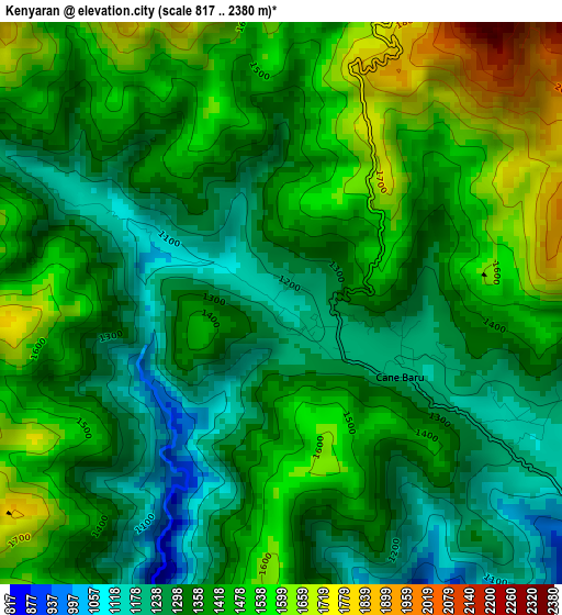
Below is the Elevation map of Kenyaran, which displays elevation range with different colors. Scale of the first map is from 817 to 2380 m (2680 to 7808 ft) with average elevation of 1405.1 meters (=4610 ft) [note 1]
These maps also provides idea of topography and contour of this city, they are displayed at different zoom levels. More info about maps, scale and edge coordinates you can find below images.
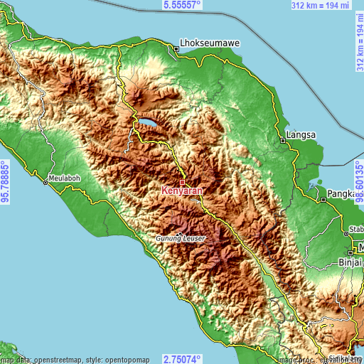
| \ | Map #1 | Topo.Map |
| Scale [m] | 817..2380 m | × |
| Scale [ft] | 2680..7808 ft | × |
| Average | 1405.1 m = 4610 ft | × |
| Width | 9.75 km = 6.1 mi | 311.9 km = 193.8 mi |
| Height | 9.75 km = 6.1 mi | 311.9 km = 193.8 mi |
| ↑Max Latitude | 4.198229° | 5.55557° |
| Latitude at center | 4.1544° | 4.1544° |
| ↓Min Latitude | 4.110569° | 2.75074° |
| ← Min Longitude | 97.151155° | 95.78885° |
| Longitude center | 97.1951° | 97.1951° |
| →Max Longitude | 97.239045° | 98.60135° |
Nearby cities:
Cities around Kenyaran sort by population:
• Blangpidie elevation 17 m
60.9 km,  220°
220°
• Kotabahagia 25 m
60.5 km,  231°
231°
• Suek 26 m
59.4 km, 224°
• Kuala Bintang 1551 m
53.4 km,  331°
331°
• Jagongjeget 1458 m
51.6 km,  300°
300°
• Isak 993 m
48.6 km,  314°
314°
• Sangir 1610 m
47.4 km,  128°
128°
• Pining 382 m
44 km,  96°
96°
• Blangkejeren 932 m
23.6 km,  137°
137°
• Terangun 766 m
16.6 km,  238°
238°
• Rikitgaib 1102 m
15.3 km,  265°
265°
• Kutapanjang 1308 m
13.8 km,  160°
160°
Multilingual:
 En español:
Kenyaran elevación 1170 m.
 En France:
Kenyaran élévation 1170 m.
 Auf Deutsch:
Kenyaran höhe über dem Meeresspiegel ist 1170 m.

Sources and notes:
- [note 1] Map square and city borders are not equal. Map elevation data is calculated only from area inside that square.
- [src 1] Elevation data from geonames database provided with same terms of usage.
- [src 2] The elevation map of Kenyaran is generated using elevation data from NASA's 3 arcsec (90m) resolution SRTM data.
- [src 3] Base (background) map © OpenStreetMap contributors tiles are generated by Geofabrik and OpenTopoMap.
Copyright & License:
This Kenyaran Elevation Map is licensed under CC BY-SA. You may reuse any part from this page, if you give a proper credit by linking to this URL:
 More info on terms of use page.