Sangir elevation
Sangir (Aceh), Indonesia elevation is 1610 meters and Sangir elevation in feet is 5282 ft above sea level [src 1]. Sangir is a seat of a third-order administrative division (feature code) with elevation that is 1419 meters (4656 ft) bigger than average city elevation in Indonesia.
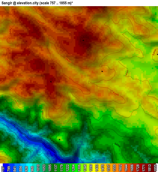
Below is the Elevation map of Sangir, which displays elevation range with different colors. Scale of the first map is from 757 to 1855 m (2484 to 6086 ft) with average elevation of 1413.6 meters (=4638 ft) [note 1]
These maps also provides idea of topography and contour of this city, they are displayed at different zoom levels. More info about maps, scale and edge coordinates you can find below images.
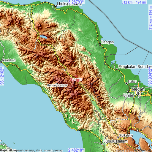
| \ | Map #1 | Topo.Map |
| Scale [m] | 757..1855 m | × |
| Scale [ft] | 2484..6086 ft | × |
| Average | 1413.6 m = 4638 ft | × |
| Width | 9.75 km = 6.1 mi | 312 km = 193.9 mi |
| Height | 9.75 km = 6.1 mi | 312 km = 193.9 mi |
| ↑Max Latitude | 3.930063° | 5.28793° |
| Latitude at center | 3.88622° | 3.88622° |
| ↓Min Latitude | 3.842375° | 2.48218° |
| ← Min Longitude | 97.483925° | 96.12162° |
| Longitude center | 97.52787° | 97.52787° |
| →Max Longitude | 97.571815° | 98.93412° |
Nearby cities:
Cities around Sangir sort by population:
• Rikitgaib elevation 1102 m
59.6 km,  298°
298°
• Ngkan 1315 m
56.1 km,  163°
163°
• Terangun 766 m
55.4 km,  292°
292°
• Tenggulun 60 m
54.4 km,  77°
77°
• Kenyaran 1170 m
47.4 km,  308°
308°
• Pulau Tiga 445 m
47.1 km,  55°
55°
• Mersak 1464 m
44.4 km,  201°
201°
• Kutapanjang 1308 m
36.4 km, 297°
• Tanah Merah 304 m
34.2 km,  145°
145°
• Seupakat 2271 m
28 km,  194°
194°
• Pining 382 m
25.4 km,  15°
15°
• Blangkejeren 932 m
24.4 km, 300°
Multilingual:
 En español:
Sangir elevación 1610 m.
 En France:
Sangir élévation 1610 m.


Sources and notes:
- [note 1] Map square and city borders are not equal. Map elevation data is calculated only from area inside that square.
- [src 1] Elevation data from geonames database provided with same terms of usage.
- [src 2] The elevation map of Sangir is generated using elevation data from NASA's 3 arcsec (90m) resolution SRTM data.
- [src 3] Base (background) map © OpenStreetMap contributors tiles are generated by Geofabrik and OpenTopoMap.
Copyright & License:
This Sangir Elevation Map is licensed under CC BY-SA. You may reuse any part from this page, if you give a proper credit by linking to this URL:
 More info on terms of use page.