Mersak elevation
Mersak (Aceh), Indonesia elevation is 1464 meters and Mersak elevation in feet is 4803 ft above sea level [src 1]. Mersak is a seat of a third-order administrative division (feature code) with elevation that is 1273 meters (4177 ft) bigger than average city elevation in Indonesia.
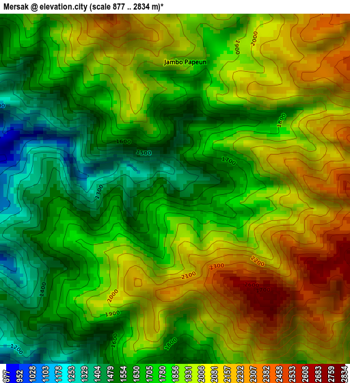
Below is the Elevation map of Mersak, which displays elevation range with different colors. Scale of the first map is from 877 to 2834 m (2877 to 9298 ft) with average elevation of 1853.4 meters (=6081 ft) [note 1]
These maps also provides idea of topography and contour of this city, they are displayed at different zoom levels. More info about maps, scale and edge coordinates you can find below images.
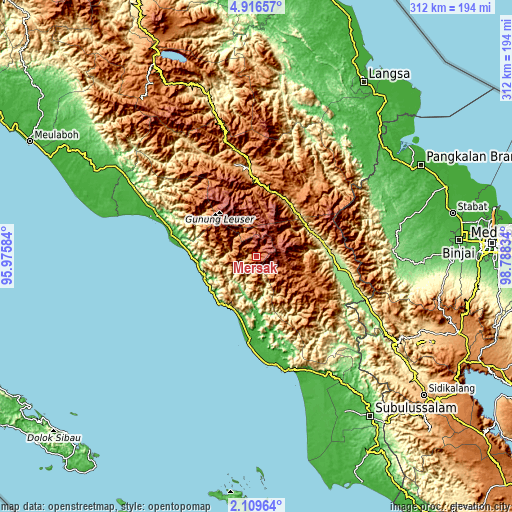
| \ | Map #1 | Topo.Map |
| Scale [m] | 877..2834 m | × |
| Scale [ft] | 2877..9298 ft | × |
| Average | 1853.4 m = 6081 ft | × |
| Width | 9.75 km = 6.1 mi | 312.1 km = 193.9 mi |
| Height | 9.75 km = 6.1 mi | 312.1 km = 193.9 mi |
| ↑Max Latitude | 3.558022° | 4.91657° |
| Latitude at center | 3.51416° | 3.51416° |
| ↓Min Latitude | 3.470296° | 2.10964° |
| ← Min Longitude | 97.338145° | 95.97584° |
| Longitude center | 97.38209° | 97.38209° |
| →Max Longitude | 97.426035° | 98.78834° |
Nearby cities:
Cities around Mersak sort by population:
• Kota Trieng elevation 40 m
47.5 km,  281°
281°
• Sangir 1610 m
44.4 km,  21°
21°
• Peuleumat 47 m
39 km,  272°
272°
• Tanah Merah 304 m
37.9 km,  69°
69°
• Meukek 40 m
35.7 km,  263°
263°
• Terbangan 79 m
35.4 km,  200°
200°
• Samadua 53 m
34.2 km,  234°
234°
• Ngkan 1315 m
34.2 km,  111°
111°
• Paya Dapur 202 m
34.1 km,  173°
173°
• Sawang 144 m
33.5 km,  248°
248°
• Pulo Ie 304 m
26 km,  186°
186°
• Seupakat 2271 m
16.9 km,  31°
31°
Multilingual:
 En español:
Mersak elevación 1464 m.
 En France:
Mersak élévation 1464 m.


Sources and notes:
- [note 1] Map square and city borders are not equal. Map elevation data is calculated only from area inside that square.
- [src 1] Elevation data from geonames database provided with same terms of usage.
- [src 2] The elevation map of Mersak is generated using elevation data from NASA's 3 arcsec (90m) resolution SRTM data.
- [src 3] Base (background) map © OpenStreetMap contributors tiles are generated by Geofabrik and OpenTopoMap.
Copyright & License:
This Mersak Elevation Map is licensed under CC BY-SA. You may reuse any part from this page, if you give a proper credit by linking to this URL:
 More info on terms of use page.