Kuala Bintang elevation
Kuala Bintang (Aceh), Indonesia elevation is 1551 meters and Kuala Bintang elevation in feet is 5089 ft above sea level [src 1]. Kuala Bintang is a seat of a third-order administrative division (feature code) with elevation that is 1360 meters (4462 ft) bigger than average city elevation in Indonesia.
Below is the Elevation map of Kuala Bintang, which displays elevation range with different colors. Scale of the first map is from 1229 to 2620 m (4032 to 8596 ft) with average elevation of 1596.7 meters (=5239 ft) [note 1]
These maps also provides idea of topography and contour of this city, they are displayed at different zoom levels. More info about maps, scale and edge coordinates you can find below images.
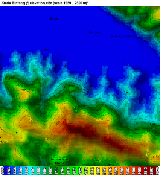
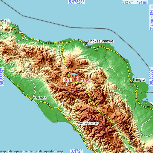
| \ | Map #1 | Topo.Map |
| Scale [m] | 1229..2620 m | × |
| Scale [ft] | 4032..8596 ft | × |
| Average | 1596.7 m = 5239 ft | × |
| Width | 9.74 km = 6.1 mi | 311.7 km = 193.7 mi |
| Height | 9.74 km = 6.1 mi | 311.7 km = 193.7 mi |
| ↑Max Latitude | 4.618804° | 5.97526° |
| Latitude at center | 4.575° | 4.575° |
| ↓Min Latitude | 4.531193° | 3.172° |
| ← Min Longitude | 96.918875° | 95.55657° |
| Longitude center | 96.96282° | 96.96282° |
| →Max Longitude | 97.006765° | 98.36907° |
Nearby cities:
Cities around Kuala Bintang sort by population:
• Rusip elevation 1092 m
40.5 km,  284°
284°
• Celala 939 m
30.1 km,  274°
274°
• Jagongjeget 1458 m
28.1 km,  222°
222°
• Angkup 996 m
27.1 km, 281°
• Kute Panang 1035 m
26.7 km,  288°
288°
• Kemil 1480 m
23.4 km, 282°
• Pegasing 1439 m
20.7 km, 270°
• Simpang Tiga Redelong 1378 m
19.1 km,  329°
329°
• Simpang Teritit 1317 m
18 km,  319°
319°
• Isak 993 m
15.6 km,  214°
214°
• Kebayakan 1241 m
14.1 km,  301°
301°
• Takengon 1256 m
13.9 km, 291°
Multilingual:
 En español:
Kuala Bintang elevación 1551 m.
 En France:
Kuala Bintang élévation 1551 m.
 Auf Deutsch:
Kuala Bintang höhe über dem Meeresspiegel ist 1551 m.

Sources and notes:
- [note 1] Map square and city borders are not equal. Map elevation data is calculated only from area inside that square.
- [src 1] Elevation data from geonames database provided with same terms of usage.
- [src 2] The elevation map of Kuala Bintang is generated using elevation data from NASA's 3 arcsec (90m) resolution SRTM data.
- [src 3] Base (background) map © OpenStreetMap contributors tiles are generated by Geofabrik and OpenTopoMap.
Copyright & License:
This Kuala Bintang Elevation Map is licensed under CC BY-SA. You may reuse any part from this page, if you give a proper credit by linking to this URL:
 More info on terms of use page.