Bambol elevation
Bambol (Aceh), Indonesia elevation is 220 meters and Bambol elevation in feet is 722 ft above sea level [src 1]. Bambol is a seat of a third-order administrative division (feature code) with elevation that is 29 meters (95 ft) bigger than average city elevation in Indonesia.
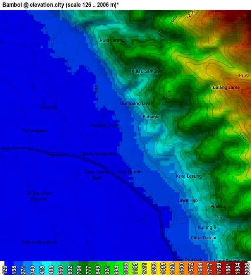
Below is the Elevation map of Bambol, which displays elevation range with different colors. Scale of the first map is from 126 to 2006 m (413 to 6581 ft) with average elevation of 459.8 meters (=1509 ft) [note 1]
These maps also provides idea of topography and contour of this city, they are displayed at different zoom levels. More info about maps, scale and edge coordinates you can find below images.
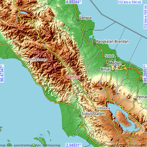
| \ | Map #1 | Topo.Map |
| Scale [m] | 126..2006 m | × |
| Scale [ft] | 413..6581 ft | × |
| Average | 459.8 m = 1509 ft | × |
| Width | 9.75 km = 6.1 mi | 312.1 km = 193.9 mi |
| Height | 9.75 km = 6.1 mi | 312.2 km = 194 mi |
| ↑Max Latitude | 3.493775° | 4.85244° |
| Latitude at center | 3.44991° | 3.44991° |
| ↓Min Latitude | 3.406043° | 2.04531° |
| ← Min Longitude | 97.835775° | 96.47347° |
| Longitude center | 97.87972° | 97.87972° |
| →Max Longitude | 97.923665° | 99.28597° |
Nearby cities:
Cities around Bambol sort by population:
• Pulopaya elevation 10 m
68.9 km,  201°
201°
• Krueng Luak 18 m
67.2 km,  191°
191°
• Sangir 1610 m
62.3 km,  321°
321°
• Tenggulun 60 m
61.8 km,  13°
13°
• Pulo Ie 304 m
61.1 km,  252°
252°
• Paya Dapur 202 m
57.8 km,  242°
242°
• Mersak 1464 m
55.7 km,  277°
277°
• Seupakat 2271 m
51 km,  294°
294°
• Tanah Merah 304 m
28.3 km, 315°
• Ngkan 1315 m
24 km,  257°
257°
• Lawepakam 261 m
18.9 km,  148°
148°
• Lawesigalagala Timur 201 m
14.8 km, 152°
Multilingual:
 En español:
Bambol elevación 220 m.
 En France:
Bambol élévation 220 m.


Sources and notes:
- [note 1] Map square and city borders are not equal. Map elevation data is calculated only from area inside that square.
- [src 1] Elevation data from geonames database provided with same terms of usage.
- [src 2] The elevation map of Bambol is generated using elevation data from NASA's 3 arcsec (90m) resolution SRTM data.
- [src 3] Base (background) map © OpenStreetMap contributors tiles are generated by Geofabrik and OpenTopoMap.
Copyright & License:
This Bambol Elevation Map is licensed under CC BY-SA. You may reuse any part from this page, if you give a proper credit by linking to this URL:
 More info on terms of use page.