Tiszalök elevation
Tiszalök (Szabolcs-Szatmár-Bereg), Hungary elevation is 93 meters and Tiszalök elevation in feet is 305 ft above sea level [src 1]. Tiszalök is a populated place (feature code) with elevation that is 36 meters (118 ft) smaller than average city elevation in Hungary.
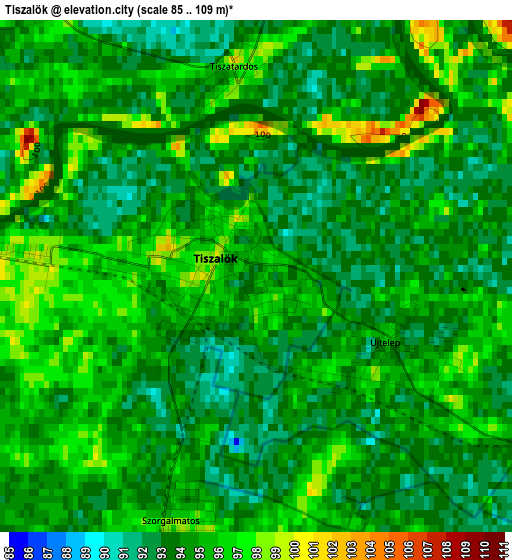
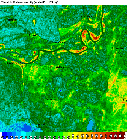
Below is the Elevation map of Tiszalök, which displays elevation range with different colors. Scale of the first map is from 85 to 109 m (279 to 358 ft) with average elevation of 94.2 meters (=309 ft) [note 1]
These maps also provides idea of topography and contour of this city, they are displayed at different zoom levels. More info about maps, scale and edge coordinates you can find below images.
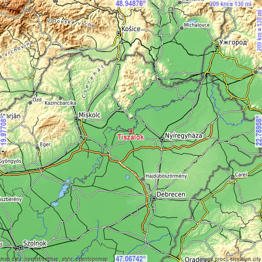
| \ | Map #1 | Map #2 | Topo.Map |
| Scale [m] | 85..109 m | 85..109 m | × |
| Scale [ft] | 279..358 ft | 279..358 ft | × |
| Average | 94.2 m = 309 ft | 93.7 m = 307 ft | × |
| Width | 6.54 km = 4.1 mi | 13.07 km = 8.1 mi | 209.2 km = 130 mi |
| Height | 6.54 km = 4.1 mi | 13.07 km = 8.1 mi | 209.2 km = 130 mi |
| ↑Max Latitude | 48.046057° | 48.075428° | 48.94876° |
| Latitude at center | 48.01667° | 48.01667° | 48.01667° |
| ↓Min Latitude | 47.987266° | 47.957845° | 47.06742° |
| ← Min Longitude | 21.339385° | 21.295439° | 19.97708° |
| Longitude center | 21.38333° | 21.38333° | 21.38333° |
| →Max Longitude | 21.427275° | 21.471221° | 22.78958° |
Nearby cities:
Cities around Tiszalök sort by population:
• Tiszavasvári elevation 93 m
6.1 km,  204°
204°
• Nyírtelek 101 m
18.6 km,  90°
90°
• Rakamaz 102 m
13.3 km,  26°
26°
• Tokaj 95 m
11.4 km,  12°
12°
• Tiszadob 90 m
16.1 km,  270°
270°
• Tarcal 147 m
13.2 km,  349°
349°
• Tiszaeszlár 95 m
7.2 km,  59°
59°
• Prügy 95 m
12.4 km,  306°
306°
• Mezőzombor 94 m
17.2 km,  329°
329°
• Tiszadada 95 m
10.1 km,  280°
280°
• Tiszanagyfalu 96 m
11.9 km,  38°
38°
• Nagycserkesz 104 m
12.5 km,  116°
116°
Multilingual:
 En español:
Tiszalök elevación 93 m.
 En France:
Tiszalök élévation 93 m.


Sources and notes:
- [note 1] Map square and city borders are not equal. Map elevation data is calculated only from area inside that square.
- [src 1] Elevation data from geonames database provided with same terms of usage.
- [src 2] The elevation map of Tiszalök is generated using elevation data from NASA's 3 arcsec (90m) resolution SRTM data.
- [src 3] Base (background) map © OpenStreetMap contributors tiles are generated by Geofabrik and OpenTopoMap.
Copyright & License:
This Tiszalök Elevation Map is licensed under CC BY-SA. You may reuse any part from this page, if you give a proper credit by linking to this URL:
 More info on terms of use page.