Győrújbarát elevation
Győrújbarát (Győr-Moson-Sopron), Hungary elevation is 124 meters and Győrújbarát elevation in feet is 407 ft above sea level [src 1]. Győrújbarát is a populated place (feature code) with elevation that is 5 meters (16 ft) smaller than average city elevation in Hungary.
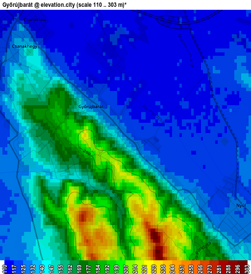
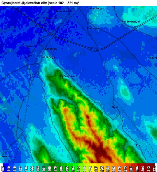
Below is the Elevation map of Győrújbarát, which displays elevation range with different colors. Scale of the first map is from 110 to 303 m (361 to 994 ft) with average elevation of 145.4 meters (=477 ft) [note 1]
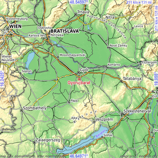
These maps also provides idea of topography and contour of this city, they are displayed at different zoom levels. More info about maps, scale and edge coordinates you can find below images.
| \ | Map #1 | Map #2 | Topo.Map |
| Scale [m] | 110..303 m | 102..321 m | × |
| Scale [ft] | 361..994 ft | 335..1053 ft | × |
| Average | 145.4 m = 477 ft | 138.7 m = 455 ft | × |
| Width | 6.59 km = 4.1 mi | 13.18 km = 8.2 mi | 210.8 km = 131 mi |
| Height | 6.59 km = 4.1 mi | 13.18 km = 8.2 mi | 210.8 km = 131 mi |
| ↑Max Latitude | 47.63605° | 47.665654° | 48.54597° |
| Latitude at center | 47.60643° | 47.60643° | 47.60643° |
| ↓Min Latitude | 47.576793° | 47.547139° | 46.64971° |
| ← Min Longitude | 17.604805° | 17.560859° | 16.2425° |
| Longitude center | 17.64875° | 17.64875° | 17.64875° |
| →Max Longitude | 17.692695° | 17.736641° | 19.055° |
Nearby cities:
Cities around Győrújbarát sort by population:
• Győr elevation 122 m
8.6 km,  353°
353°
• Tét 131 m
14.3 km,  227°
227°
• Pannonhalma 170 m
10.2 km,  128°
128°
• Nyúl 125 m
3.5 km,  120°
120°
• Abda 111 m
12.5 km,  321°
321°
• Győrszemere 127 m
8.8 km, 226°
• Öttevény 113 m
17.6 km, 315°
• Rábapatona 111 m
13 km,  282°
282°
• Pér 128 m
11.8 km,  87°
87°
• Mosonszentmiklós 118 m
21.3 km,  309°
309°
• Bőny 125 m
17.3 km,  73°
73°
• Töltéstava 121 m
6.7 km, 71°
Multilingual:
 En español:
Győrújbarát elevación 124 m.
 En France:
Győrújbarát élévation 124 m.
 Auf Deutsch:
Győrújbarát höhe über dem Meeresspiegel ist 124 m.

Sources and notes:
- [note 1] Map square and city borders are not equal. Map elevation data is calculated only from area inside that square.
- [src 1] Elevation data from geonames database provided with same terms of usage.
- [src 2] The elevation map of Győrújbarát is generated using elevation data from NASA's 3 arcsec (90m) resolution SRTM data.
- [src 3] Base (background) map © OpenStreetMap contributors tiles are generated by Geofabrik and OpenTopoMap.
Copyright & License:
This Győrújbarát Elevation Map is licensed under CC BY-SA. You may reuse any part from this page, if you give a proper credit by linking to this URL:
 More info on terms of use page.