Kiskőrös elevation
Kiskőrös (Bács-Kiskun), Hungary elevation is 100 meters and Kiskőrös elevation in feet is 328 ft above sea level [src 1]. Kiskőrös is a seat of a second-order administrative division (feature code) with elevation that is 29 meters (95 ft) smaller than average city elevation in Hungary.
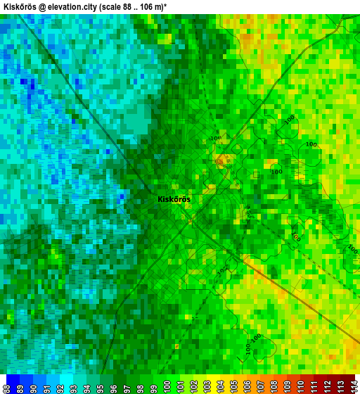
Below is the Elevation map of Kiskőrös, which displays elevation range with different colors. Scale of the first map is from 88 to 106 m (289 to 348 ft) with average elevation of 97.3 meters (=319 ft) [note 1]
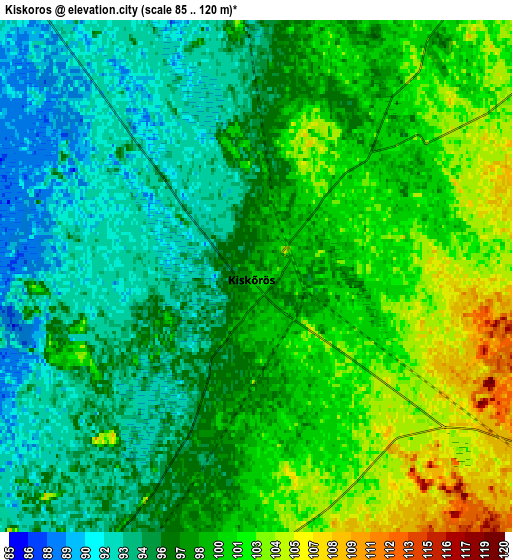
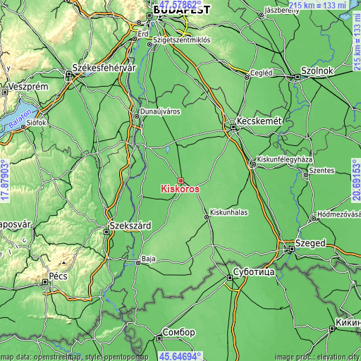
These maps also provides idea of topography and contour of this city, they are displayed at different zoom levels. More info about maps, scale and edge coordinates you can find below images.
| \ | Map #1 | Map #2 | Topo.Map |
| Scale [m] | 88..106 m | 85..120 m | × |
| Scale [ft] | 289..348 ft | 279..394 ft | × |
| Average | 97.3 m = 319 ft | 97.9 m = 321 ft | × |
| Width | 6.71 km = 4.2 mi | 13.42 km = 8.3 mi | 214.8 km = 133.5 mi |
| Height | 6.71 km = 4.2 mi | 13.42 km = 8.3 mi | 214.8 km = 133.5 mi |
| ↑Max Latitude | 46.651564° | 46.681721° | 47.57862° |
| Latitude at center | 46.62139° | 46.62139° | 46.62139° |
| ↓Min Latitude | 46.591199° | 46.560992° | 45.64694° |
| ← Min Longitude | 19.241335° | 19.197389° | 17.87903° |
| Longitude center | 19.28528° | 19.28528° | 19.28528° |
| →Max Longitude | 19.329225° | 19.373171° | 20.69153° |
Nearby cities:
Cities around Kiskőrös sort by population:
• Kiskunhalas elevation 127 m
25.8 km,  143°
143°
• Kecel 102 m
11 km,  193°
193°
• Soltvadkert 111 m
9.5 km,  119°
119°
• Izsák 101 m
21 km,  13°
13°
• Harta 87 m
21.2 km,  293°
293°
• Dunapataj 94 m
22.2 km,  276°
276°
• Akasztó 92 m
10 km,  321°
321°
• Orgovány 107 m
20.3 km,  44°
44°
• Császártöltés 109 m
23.5 km,  199°
199°
• Fülöpszállás 96 m
22.5 km,  350°
350°
• Csengőd 96 m
10.5 km, 352°
• Tázlár 114 m
19.3 km,  114°
114°
Multilingual:
 En español:
Kiskőrös elevación 100 m.
 En France:
Kiskőrös élévation 100 m.
 Auf Deutsch:
Kiskőrös höhe über dem Meeresspiegel ist 100 m.

Sources and notes:
- [note 1] Map square and city borders are not equal. Map elevation data is calculated only from area inside that square.
- [src 1] Elevation data from geonames database provided with same terms of usage.
- [src 2] The elevation map of Kiskőrös is generated using elevation data from NASA's 3 arcsec (90m) resolution SRTM data.
- [src 3] Base (background) map © OpenStreetMap contributors tiles are generated by Geofabrik and OpenTopoMap.
Copyright & License:
This Kiskőrös Elevation Map is licensed under CC BY-SA. You may reuse any part from this page, if you give a proper credit by linking to this URL:
 More info on terms of use page.