Rétság elevation
Rétság (Nógrád), Hungary elevation is 189 meters and Rétság elevation in feet is 620 ft above sea level [src 1]. Rétság is a populated place (feature code) with elevation that is 60 meters (197 ft) bigger than average city elevation in Hungary.
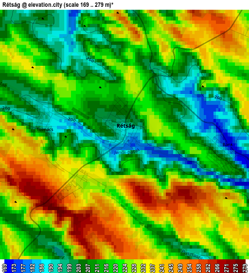
Below is the Elevation map of Rétság, which displays elevation range with different colors. Scale of the first map is from 169 to 279 m (554 to 915 ft) with average elevation of 220.7 meters (=724 ft) [note 1]
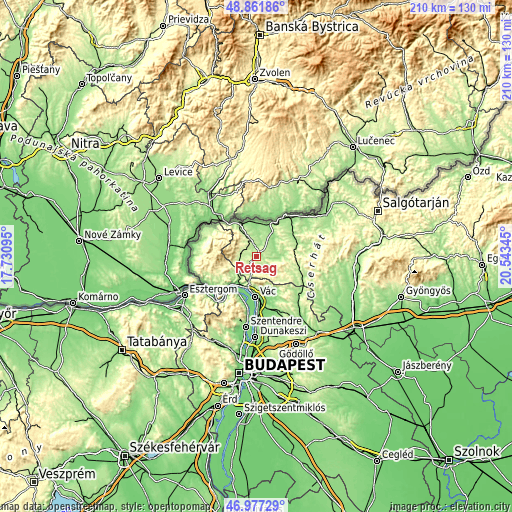
These maps also provides idea of topography and contour of this city, they are displayed at different zoom levels. More info about maps, scale and edge coordinates you can find below images.
| \ | Map #1 | Topo.Map |
| Scale [m] | 169..279 m | × |
| Scale [ft] | 554..915 ft | × |
| Average | 220.7 m = 724 ft | × |
| Width | 6.55 km = 4.1 mi | 209.5 km = 130.2 mi |
| Height | 6.55 km = 4.1 mi | 209.5 km = 130.2 mi |
| ↑Max Latitude | 47.957598° | 48.86186° |
| Latitude at center | 47.92816° | 47.92816° |
| ↓Min Latitude | 47.898706° | 46.97729° |
| ← Min Longitude | 19.093255° | 17.73095° |
| Longitude center | 19.1372° | 19.1372° |
| →Max Longitude | 19.181145° | 20.54345° |
Nearby cities:
Cities around Rétság sort by population:
• Vác elevation 113 m
16.9 km,  180°
180°
• Balassagyarmat 150 m
20 km,  36°
36°
• Tahitótfalu 103 m
20 km,  187°
187°
• Nagymaros 107 m
20 km,  221°
221°
• Érsekvadkert 175 m
9 km,  32°
32°
• Verőce 113 m
13.8 km,  213°
213°
• Dunabogdány 106 m
16.9 km, 205°
• Diósjenő 250 m
7.1 km,  280°
280°
• Romhány 167 m
8.9 km,  91°
91°
• Kosd 157 m
13.7 km,  167°
167°
• Nagyoroszi 196 m
9.2 km,  337°
337°
• Kismaros 132 m
14.1 km, 224°
Multilingual:
 En español:
Rétság elevación 189 m.
 En France:
Rétság élévation 189 m.


Sources and notes:
- [note 1] Map square and city borders are not equal. Map elevation data is calculated only from area inside that square.
- [src 1] Elevation data from geonames database provided with same terms of usage.
- [src 2] The elevation map of Rétság is generated using elevation data from NASA's 3 arcsec (90m) resolution SRTM data.
- [src 3] Base (background) map © OpenStreetMap contributors tiles are generated by Geofabrik and OpenTopoMap.
Copyright & License:
This Rétság Elevation Map is licensed under CC BY-SA. You may reuse any part from this page, if you give a proper credit by linking to this URL:
 More info on terms of use page.