Nagymaros elevation
Nagymaros (Pest), Hungary elevation is 107 meters and Nagymaros elevation in feet is 351 ft above sea level [src 1]. Nagymaros is a populated place (feature code) with elevation that is 22 meters (72 ft) smaller than average city elevation in Hungary.
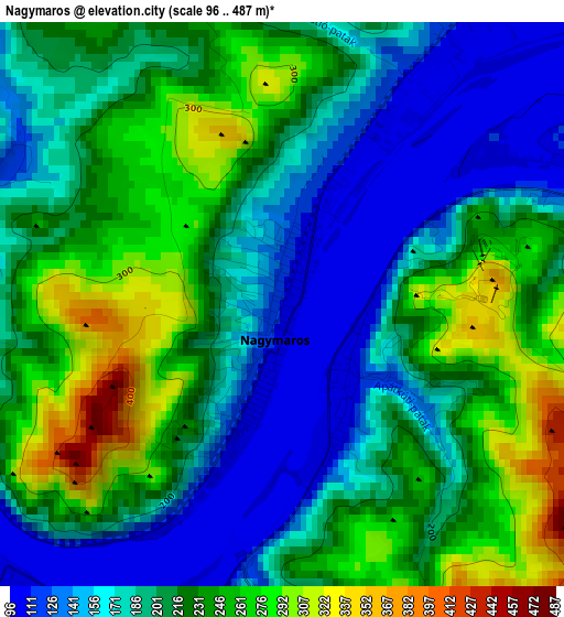
Below is the Elevation map of Nagymaros, which displays elevation range with different colors. Scale of the first map is from 96 to 487 m (315 to 1598 ft) with average elevation of 208.8 meters (=685 ft) [note 1]
These maps also provides idea of topography and contour of this city, they are displayed at different zoom levels. More info about maps, scale and edge coordinates you can find below images.
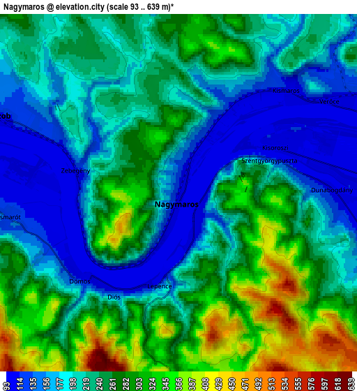
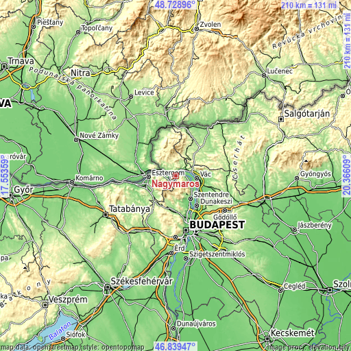
| \ | Map #1 | Map #2 | Topo.Map |
| Scale [m] | 96..487 m | 93..639 m | × |
| Scale [ft] | 315..1598 ft | 305..2096 ft | × |
| Average | 208.8 m = 685 ft | 236.1 m = 775 ft | × |
| Width | 6.57 km = 4.1 mi | 13.13 km = 8.2 mi | 210.1 km = 130.5 mi |
| Height | 6.57 km = 4.1 mi | 13.13 km = 8.2 mi | 210.1 km = 130.5 mi |
| ↑Max Latitude | 47.822315° | 47.851813° | 48.72896° |
| Latitude at center | 47.7928° | 47.7928° | 47.7928° |
| ↓Min Latitude | 47.763269° | 47.73372° | 46.83947° |
| ← Min Longitude | 18.915895° | 18.871949° | 17.55359° |
| Longitude center | 18.95984° | 18.95984° | 18.95984° |
| →Max Longitude | 19.003785° | 19.047731° | 20.36609° |
Nearby cities:
Cities around Nagymaros sort by population:
• Vác elevation 113 m
13.3 km,  98°
98°
• Tahitótfalu 103 m
11.5 km,  114°
114°
• Verőce 113 m
6.6 km,  57°
57°
• Szob 111 m
7.3 km,  293°
293°
• Dunabogdány 106 m
6.1 km,  92°
92°
• Kesztölc 204 m
14.8 km,  232°
232°
• Leányfalu 123 m
12.6 km,  131°
131°
• Pilisszántó 223 m
14.8 km,  201°
201°
• Pilisszentkereszt 335 m
12 km, 199°
• Pilismarót 122 m
6.4 km,  261°
261°
• Kismaros 132 m
6 km,  33°
33°
• Visegrád 110 m
1.2 km,  135°
135°
Multilingual:
 En español:
Nagymaros elevación 107 m.
 En France:
Nagymaros élévation 107 m.
 Auf Deutsch:
Nagymaros höhe über dem Meeresspiegel ist 107 m.

Sources and notes:
- [note 1] Map square and city borders are not equal. Map elevation data is calculated only from area inside that square.
- [src 1] Elevation data from geonames database provided with same terms of usage.
- [src 2] The elevation map of Nagymaros is generated using elevation data from NASA's 3 arcsec (90m) resolution SRTM data.
- [src 3] Base (background) map © OpenStreetMap contributors tiles are generated by Geofabrik and OpenTopoMap.
Copyright & License:
This Nagymaros Elevation Map is licensed under CC BY-SA. You may reuse any part from this page, if you give a proper credit by linking to this URL:
 More info on terms of use page.