Balassagyarmat elevation
Balassagyarmat (Nógrád), Hungary elevation is 150 meters and Balassagyarmat elevation in feet is 492 ft above sea level [src 1]. Balassagyarmat is a seat of a second-order administrative division (feature code) with elevation that is 21 meters (69 ft) bigger than average city elevation in Hungary.
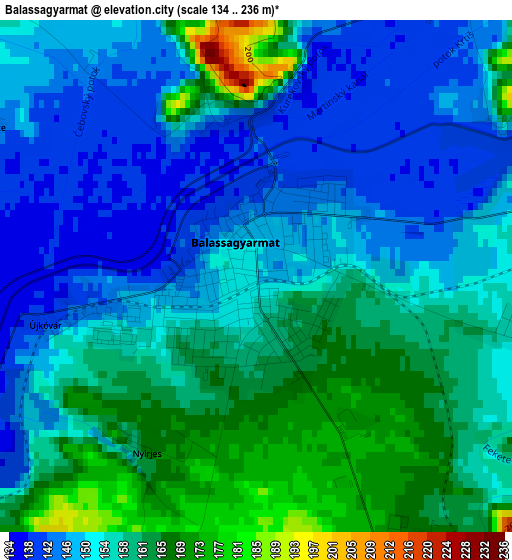
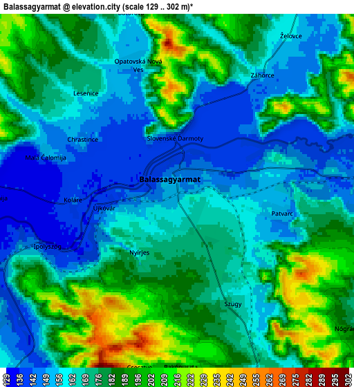
Below is the Elevation map of Balassagyarmat, which displays elevation range with different colors. Scale of the first map is from 134 to 236 m (440 to 774 ft) with average elevation of 154.3 meters (=506 ft) [note 1]
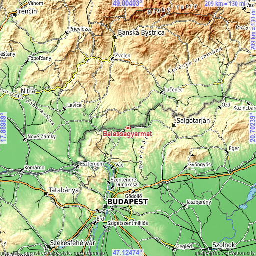
These maps also provides idea of topography and contour of this city, they are displayed at different zoom levels. More info about maps, scale and edge coordinates you can find below images.
| \ | Map #1 | Map #2 | Topo.Map |
| Scale [m] | 134..236 m | 129..302 m | × |
| Scale [ft] | 440..774 ft | 423..991 ft | × |
| Average | 154.3 m = 506 ft | 172.3 m = 565 ft | × |
| Width | 6.53 km = 4.1 mi | 13.06 km = 8.1 mi | 209 km = 129.9 mi |
| Height | 6.53 km = 4.1 mi | 13.06 km = 8.1 mi | 208.9 km = 129.8 mi |
| ↑Max Latitude | 48.102315° | 48.131654° | 49.00403° |
| Latitude at center | 48.07296° | 48.07296° | 48.07296° |
| ↓Min Latitude | 48.043588° | 48.014199° | 47.12474° |
| ← Min Longitude | 19.252195° | 19.208249° | 17.88989° |
| Longitude center | 19.29614° | 19.29614° | 19.29614° |
| →Max Longitude | 19.340085° | 19.384031° | 20.70239° |
Nearby cities:
Cities around Balassagyarmat sort by population:
• Szécsény elevation 172 m
16.7 km,  87°
87°
• Érsekvadkert 175 m
11 km,  219°
219°
• Rétság 189 m
20 km, 216°
• Diósjenő 250 m
24 km,  231°
231°
• Romhány 167 m
16.6 km,  190°
190°
• Kosd 157 m
30.8 km,  196°
196°
• Buják 181 m
28 km,  138°
138°
• Nagyoroszi 196 m
17.1 km,  243°
243°
• Bercel 216 m
24 km,  159°
159°
• Karancskeszi 184 m
31.4 km,  71°
71°
• Rimóc 178 m
17.8 km,  102°
102°
• Acsa 175 m
31.7 km,  167°
167°
Multilingual:
 En español:
Balassagyarmat elevación 150 m.
 En France:
Balassagyarmat élévation 150 m.
 Auf Deutsch:
Balassagyarmat höhe über dem Meeresspiegel ist 150 m.

Sources and notes:
- [note 1] Map square and city borders are not equal. Map elevation data is calculated only from area inside that square.
- [src 1] Elevation data from geonames database provided with same terms of usage.
- [src 2] The elevation map of Balassagyarmat is generated using elevation data from NASA's 3 arcsec (90m) resolution SRTM data.
- [src 3] Base (background) map © OpenStreetMap contributors tiles are generated by Geofabrik and OpenTopoMap.
Copyright & License:
This Balassagyarmat Elevation Map is licensed under CC BY-SA. You may reuse any part from this page, if you give a proper credit by linking to this URL:
 More info on terms of use page.