Tamási elevation
Tamási (Tolna), Hungary elevation is 126 meters and Tamási elevation in feet is 413 ft above sea level [src 1]. Tamási is a seat of a second-order administrative division (feature code) with elevation that is 3 meters (10 ft) smaller than average city elevation in Hungary.
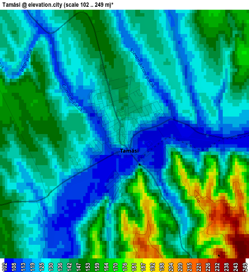
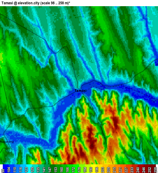
Below is the Elevation map of Tamási, which displays elevation range with different colors. Scale of the first map is from 102 to 249 m (335 to 817 ft) with average elevation of 139.4 meters (=457 ft) [note 1]
These maps also provides idea of topography and contour of this city, they are displayed at different zoom levels. More info about maps, scale and edge coordinates you can find below images.
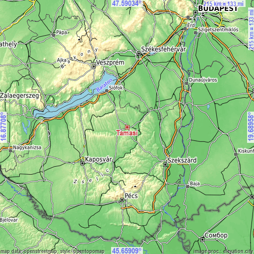
| \ | Map #1 | Map #2 | Topo.Map |
| Scale [m] | 102..249 m | 98..258 m | × |
| Scale [ft] | 335..817 ft | 322..846 ft | × |
| Average | 139.4 m = 457 ft | 150.1 m = 492 ft | × |
| Width | 6.71 km = 4.2 mi | 13.42 km = 8.3 mi | 214.7 km = 133.4 mi |
| Height | 6.71 km = 4.2 mi | 13.42 km = 8.3 mi | 214.7 km = 133.4 mi |
| ↑Max Latitude | 46.663497° | 46.693648° | 47.59034° |
| Latitude at center | 46.63333° | 46.63333° | 46.63333° |
| ↓Min Latitude | 46.603146° | 46.572945° | 45.65909° |
| ← Min Longitude | 18.239385° | 18.195439° | 16.87708° |
| Longitude center | 18.28333° | 18.28333° | 18.28333° |
| →Max Longitude | 18.327275° | 18.371221° | 19.68958° |
Nearby cities:
Cities around Tamási sort by population:
• Tab elevation 173 m
22.1 km,  299°
299°
• Simontornya 96 m
24.7 km,  56°
56°
• Hőgyész 156 m
18.3 km,  145°
145°
• Nagydorog 104 m
28.4 km,  91°
91°
• Iregszemcse 163 m
10 km,  311°
311°
• Pincehely 110 m
13 km,  66°
66°
• Lajoskomárom 145 m
23.6 km,  10°
10°
• Mezőszilas 124 m
24.7 km,  36°
36°
• Ádánd 118 m
26.7 km,  340°
340°
• Gyönk 138 m
17.1 km,  120°
120°
• Döbrököz 121 m
23.8 km,  188°
188°
• Ozora 107 m
15.9 km,  34°
34°
Multilingual:
 En español:
Tamási elevación 126 m.
 En France:
Tamási élévation 126 m.


Sources and notes:
- [note 1] Map square and city borders are not equal. Map elevation data is calculated only from area inside that square.
- [src 1] Elevation data from geonames database provided with same terms of usage.
- [src 2] The elevation map of Tamási is generated using elevation data from NASA's 3 arcsec (90m) resolution SRTM data.
- [src 3] Base (background) map © OpenStreetMap contributors tiles are generated by Geofabrik and OpenTopoMap.
Copyright & License:
This Tamási Elevation Map is licensed under CC BY-SA. You may reuse any part from this page, if you give a proper credit by linking to this URL:
 More info on terms of use page.