Döbrököz elevation
Döbrököz (Tolna), Hungary elevation is 121 meters and Döbrököz elevation in feet is 397 ft above sea level [src 1]. Döbrököz is a populated place (feature code) with elevation that is 8 meters (26 ft) smaller than average city elevation in Hungary.
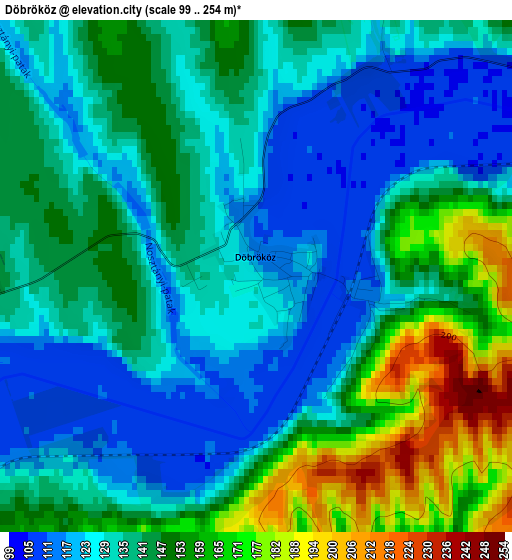
Below is the Elevation map of Döbrököz, which displays elevation range with different colors. Scale of the first map is from 99 to 254 m (325 to 833 ft) with average elevation of 139.8 meters (=459 ft) [note 1]
These maps also provides idea of topography and contour of this city, they are displayed at different zoom levels. More info about maps, scale and edge coordinates you can find below images.
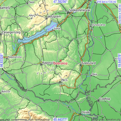
| \ | Map #1 | Topo.Map |
| Scale [m] | 99..254 m | × |
| Scale [ft] | 325..833 ft | × |
| Average | 139.8 m = 459 ft | × |
| Width | 6.74 km = 4.2 mi | 215.6 km = 134 mi |
| Height | 6.74 km = 4.2 mi | 215.6 km = 134 mi |
| ↑Max Latitude | 46.452065° | 47.38256° |
| Latitude at center | 46.42178° | 46.42178° |
| ↓Min Latitude | 46.391478° | 45.44377° |
| ← Min Longitude | 18.195585° | 16.83328° |
| Longitude center | 18.23953° | 18.23953° |
| →Max Longitude | 18.283475° | 19.64578° |
Nearby cities:
Cities around Döbrököz sort by population:
• Komló elevation 246 m
25.5 km,  175°
175°
• Dombóvár 131 m
9.3 km,  237°
237°
• Bonyhád 122 m
26.1 km,  121°
121°
• Tamási 126 m
23.8 km,  8°
8°
• Sásd 134 m
21.1 km,  208°
208°
• Hőgyész 156 m
16.1 km,  58°
58°
• Szászvár 162 m
19.2 km,  147°
147°
• Mágocs 171 m
8 km, 183°
• Nagymányok 132 m
22.9 km,  133°
133°
• Zomba 120 m
25 km,  92°
92°
• Gyönk 138 m
23.5 km,  50°
50°
• Taszár 136 m
26.1 km,  258°
258°
Multilingual:
 En español:
Döbrököz elevación 121 m.
 En France:
Döbrököz élévation 121 m.
 Auf Deutsch:
Döbrököz höhe über dem Meeresspiegel ist 121 m.

Sources and notes:
- [note 1] Map square and city borders are not equal. Map elevation data is calculated only from area inside that square.
- [src 1] Elevation data from geonames database provided with same terms of usage.
- [src 2] The elevation map of Döbrököz is generated using elevation data from NASA's 3 arcsec (90m) resolution SRTM data.
- [src 3] Base (background) map © OpenStreetMap contributors tiles are generated by Geofabrik and OpenTopoMap.
Copyright & License:
This Döbrököz Elevation Map is licensed under CC BY-SA. You may reuse any part from this page, if you give a proper credit by linking to this URL:
 More info on terms of use page.