Simontornya elevation
Simontornya (Tolna), Hungary elevation is 96 meters and Simontornya elevation in feet is 315 ft above sea level [src 1]. Simontornya is a populated place (feature code) with elevation that is 33 meters (108 ft) smaller than average city elevation in Hungary.
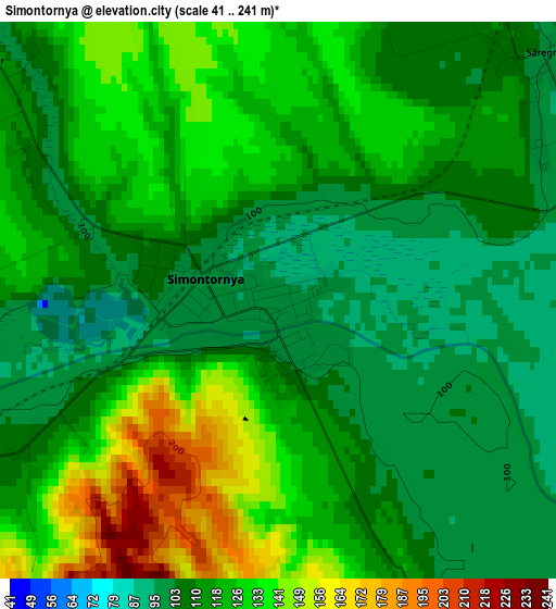
Below is the Elevation map of Simontornya, which displays elevation range with different colors. Scale of the first map is from 41 to 241 m (135 to 791 ft) with average elevation of 119.1 meters (=391 ft) [note 1]
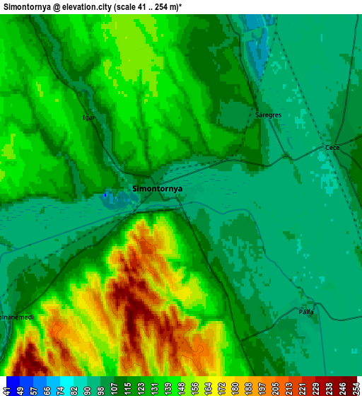
These maps also provides idea of topography and contour of this city, they are displayed at different zoom levels. More info about maps, scale and edge coordinates you can find below images.
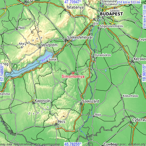
| \ | Map #1 | Map #2 | Topo.Map |
| Scale [m] | 41..241 m | 41..254 m | × |
| Scale [ft] | 135..791 ft | 135..833 ft | × |
| Average | 119.1 m = 391 ft | 122.8 m = 403 ft | × |
| Width | 6.7 km = 4.2 mi | 13.39 km = 8.3 mi | 214.3 km = 133.2 mi |
| Height | 6.7 km = 4.2 mi | 13.39 km = 8.3 mi | 214.2 km = 133.1 mi |
| ↑Max Latitude | 46.78472° | 46.814802° | 47.70947° |
| Latitude at center | 46.75462° | 46.75462° | 46.75462° |
| ↓Min Latitude | 46.724504° | 46.69437° | 45.78255° |
| ← Min Longitude | 18.510955° | 18.467009° | 17.14865° |
| Longitude center | 18.5549° | 18.5549° | 18.5549° |
| →Max Longitude | 18.598845° | 18.642791° | 19.96115° |
Nearby cities:
Cities around Simontornya sort by population:
• Sárbogárd elevation 107 m
15.5 km,  18°
18°
• Cece 102 m
5.9 km,  72°
72°
• Nagydorog 104 m
16.1 km,  151°
151°
• Előszállás 107 m
22.9 km, 68°
• Pincehely 110 m
12 km,  227°
227°
• Lajoskomárom 145 m
19.2 km,  300°
300°
• Dég 125 m
14.9 km,  327°
327°
• Mezőszilas 124 m
8.6 km,  316°
316°
• Alap 107 m
11.4 km,  64°
64°
• Gyönk 138 m
22.9 km,  195°
195°
• Németkér 148 m
16.4 km,  105°
105°
• Ozora 107 m
11.8 km,  268°
268°
Multilingual:
 En español:
Simontornya elevación 96 m.
 En France:
Simontornya élévation 96 m.
 Auf Deutsch:
Simontornya höhe über dem Meeresspiegel ist 96 m.

Sources and notes:
- [note 1] Map square and city borders are not equal. Map elevation data is calculated only from area inside that square.
- [src 1] Elevation data from geonames database provided with same terms of usage.
- [src 2] The elevation map of Simontornya is generated using elevation data from NASA's 3 arcsec (90m) resolution SRTM data.
- [src 3] Base (background) map © OpenStreetMap contributors tiles are generated by Geofabrik and OpenTopoMap.
Copyright & License:
This Simontornya Elevation Map is licensed under CC BY-SA. You may reuse any part from this page, if you give a proper credit by linking to this URL:
 More info on terms of use page.