Dubrava elevation
Dubrava (City of Zagreb), Croatia elevation is 130 meters and Dubrava elevation in feet is 427 ft above sea level [src 1]. Dubrava is a section of populated place (feature code) with elevation that is 24 meters (79 ft) smaller than average city elevation in Croatia.
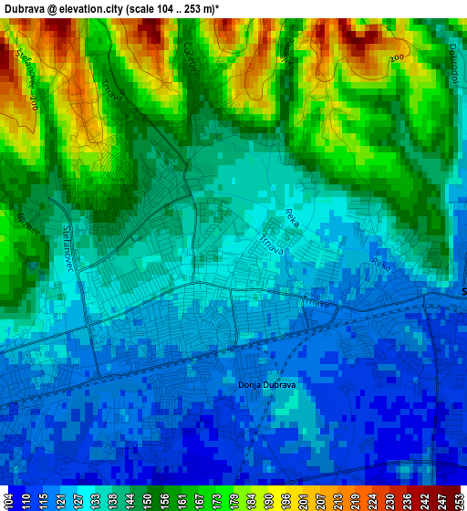
Below is the Elevation map of Dubrava, which displays elevation range with different colors. Scale of the first map is from 104 to 253 m (341 to 830 ft) with average elevation of 142.9 meters (=469 ft) [note 1]
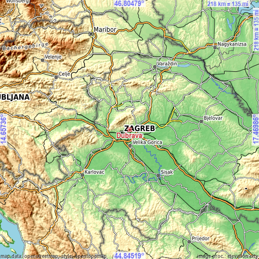
These maps also provides idea of topography and contour of this city, they are displayed at different zoom levels. More info about maps, scale and edge coordinates you can find below images.
| \ | Map #1 | Topo.Map |
| Scale [m] | 104..253 m | × |
| Scale [ft] | 341..830 ft | × |
| Average | 142.9 m = 469 ft | × |
| Width | 6.81 km = 4.2 mi | 217.9 km = 135.4 mi |
| Height | 6.81 km = 4.2 mi | 217.9 km = 135.4 mi |
| ↑Max Latitude | 45.86422° | 46.80479° |
| Latitude at center | 45.83361° | 45.83361° |
| ↓Min Latitude | 45.802983° | 44.84519° |
| ← Min Longitude | 16.019665° | 14.65736° |
| Longitude center | 16.06361° | 16.06361° |
| →Max Longitude | 16.107555° | 17.46986° |
Nearby cities:
Cities around Dubrava sort by population:
• Zagreb elevation 135 m
7 km,  252°
252°
• Sesvete 142 m
4.1 km,  93°
93°
• Centar 134 m
7 km, 251°
• Velika Gorica 107 m
13.5 km,  176°
176°
• Jankomir 121 m
13.5 km, 249°
• Novi Zagreb 119 m
8.4 km,  228°
228°
• Velika Mlaka 110 m
11.1 km,  193°
193°
• Donja Lomnica 108 m
13.8 km, 191°
• Odra 113 m
12.8 km,  205°
205°
• Kašina 184 m
9.8 km,  28°
28°
• Mičevec 106 m
9.3 km, 178°
• Dugo Selo 113 m
14.3 km,  102°
102°
Multilingual:
 En español:
Dubrava elevación 130 m.
 En France:
Dubrava élévation 130 m.


Sources and notes:
- [note 1] Map square and city borders are not equal. Map elevation data is calculated only from area inside that square.
- [src 1] Elevation data from geonames database provided with same terms of usage.
- [src 2] The elevation map of Dubrava is generated using elevation data from NASA's 3 arcsec (90m) resolution SRTM data.
- [src 3] Base (background) map © OpenStreetMap contributors tiles are generated by Geofabrik and OpenTopoMap.
Copyright & License:
This Dubrava Elevation Map is licensed under CC BY-SA. You may reuse any part from this page, if you give a proper credit by linking to this URL:
 More info on terms of use page.