Jankomir elevation
Jankomir (City of Zagreb), Croatia elevation is 121 meters and Jankomir elevation in feet is 397 ft above sea level [src 1]. Jankomir is a populated place (feature code) with elevation that is 33 meters (108 ft) smaller than average city elevation in Croatia.
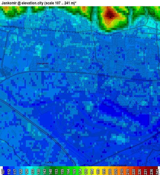
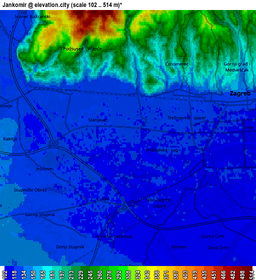
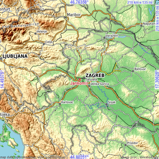
Below is the Elevation map of Jankomir, which displays elevation range with different colors. Scale of the first map is from 107 to 241 m (351 to 791 ft) with average elevation of 122.1 meters (=401 ft) [note 1]
These maps also provides idea of topography and contour of this city, they are displayed at different zoom levels. More info about maps, scale and edge coordinates you can find below images.
| \ | Map #1 | Map #2 | Topo.Map |
| Scale [m] | 107..241 m | 102..514 m | × |
| Scale [ft] | 351..791 ft | 335..1686 ft | × |
| Average | 122.1 m = 401 ft | 152.3 m = 500 ft | × |
| Width | 6.81 km = 4.2 mi | 13.63 km = 8.5 mi | 218.1 km = 135.5 mi |
| Height | 6.81 km = 4.2 mi | 13.63 km = 8.5 mi | 218 km = 135.5 mi |
| ↑Max Latitude | 45.822303° | 45.85292° | 46.76358° |
| Latitude at center | 45.79167° | 45.79167° | 45.79167° |
| ↓Min Latitude | 45.76102° | 45.730353° | 44.80251° |
| ← Min Longitude | 15.856055° | 15.812109° | 14.49375° |
| Longitude center | 15.9° | 15.9° | 15.9° |
| →Max Longitude | 15.943945° | 15.987891° | 17.30625° |
Nearby cities:
Cities around Jankomir sort by population:
• Zagreb elevation 135 m
6.6 km,  67°
67°
• Stenjevec 118 m
2.3 km,  323°
323°
• Centar 134 m
6.5 km, 68°
• Brezovica 118 m
7 km,  173°
173°
• Novi Zagreb 119 m
6.5 km,  98°
98°
• Lučko 116 m
4.1 km,  214°
214°
• Bestovje 125 m
6.7 km,  286°
286°
• Rakitje 135 m
6 km,  272°
272°
• Kerestinec 139 m
7.5 km,  251°
251°
• Donji Stupnik 126 m
6.6 km, 208°
• Ježdovec 125 m
4 km,  256°
256°
• Zadvorsko 119 m
8 km,  175°
175°
Multilingual:
 En español:
Jankomir elevación 121 m.
 En France:
Jankomir élévation 121 m.
 Auf Deutsch:
Jankomir höhe über dem Meeresspiegel ist 121 m.

Sources and notes:
- [note 1] Map square and city borders are not equal. Map elevation data is calculated only from area inside that square.
- [src 1] Elevation data from geonames database provided with same terms of usage.
- [src 2] The elevation map of Jankomir is generated using elevation data from NASA's 3 arcsec (90m) resolution SRTM data.
- [src 3] Base (background) map © OpenStreetMap contributors tiles are generated by Geofabrik and OpenTopoMap.
Copyright & License:
This Jankomir Elevation Map is licensed under CC BY-SA. You may reuse any part from this page, if you give a proper credit by linking to this URL:
 More info on terms of use page.