Kašina elevation
Kašina (City of Zagreb), Croatia elevation is 184 meters and Kašina elevation in feet is 604 ft above sea level [src 1]. Kašina is a populated place (feature code) with elevation that is 30 meters (98 ft) bigger than average city elevation in Croatia.
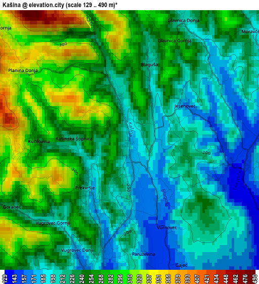
Below is the Elevation map of Kašina, which displays elevation range with different colors. Scale of the first map is from 129 to 490 m (423 to 1608 ft) with average elevation of 240.5 meters (=789 ft) [note 1]
These maps also provides idea of topography and contour of this city, they are displayed at different zoom levels. More info about maps, scale and edge coordinates you can find below images.
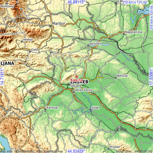
| \ | Map #1 | Topo.Map |
| Scale [m] | 129..490 m | × |
| Scale [ft] | 423..1608 ft | × |
| Average | 240.5 m = 789 ft | × |
| Width | 6.8 km = 4.2 mi | 217.6 km = 135.2 mi |
| Height | 6.8 km = 4.2 mi | 217.6 km = 135.2 mi |
| ↑Max Latitude | 45.941907° | 46.88115° |
| Latitude at center | 45.91134° | 45.91134° |
| ↓Min Latitude | 45.880756° | 44.92429° |
| ← Min Longitude | 16.080415° | 14.71811° |
| Longitude center | 16.12436° | 16.12436° |
| →Max Longitude | 16.168305° | 17.53061° |
Nearby cities:
Cities around Kašina sort by population:
• Zagreb elevation 135 m
15.6 km,  226°
226°
• Sesvete 142 m
8.9 km,  183°
183°
• Centar 134 m
15.8 km, 226°
• Dubrava 130 m
9.8 km,  208°
208°
• Brckovljani 171 m
16.1 km,  122°
122°
• Marija Bistrica 175 m
10.6 km,  354°
354°
• Konjšćina 164 m
16.1 km,  13°
13°
• Rakovec 119 m
15.5 km,  82°
82°
• Dugo Selo 113 m
14.9 km,  141°
141°
• Donja Stubica 177 m
14.6 km,  303°
303°
• Gornja Stubica 207 m
10.8 km,  311°
311°
• Sveti Ivan Zelina 179 m
10.7 km,  62°
62°
Multilingual:
 En español:
Kašina elevación 184 m.
 En France:
Kašina élévation 184 m.


Sources and notes:
- [note 1] Map square and city borders are not equal. Map elevation data is calculated only from area inside that square.
- [src 1] Elevation data from geonames database provided with same terms of usage.
- [src 2] The elevation map of Kašina is generated using elevation data from NASA's 3 arcsec (90m) resolution SRTM data.
- [src 3] Base (background) map © OpenStreetMap contributors tiles are generated by Geofabrik and OpenTopoMap.
Copyright & License:
This Kašina Elevation Map is licensed under CC BY-SA. You may reuse any part from this page, if you give a proper credit by linking to this URL:
 More info on terms of use page.