Dugo Selo elevation
Dugo Selo (Zagrebačka, Grad Dugo Selo), Croatia elevation is 113 meters and Dugo Selo elevation in feet is 371 ft above sea level [src 1]. Dugo Selo is a seat of a second-order administrative division (feature code) with elevation that is 41 meters (135 ft) smaller than average city elevation in Croatia.
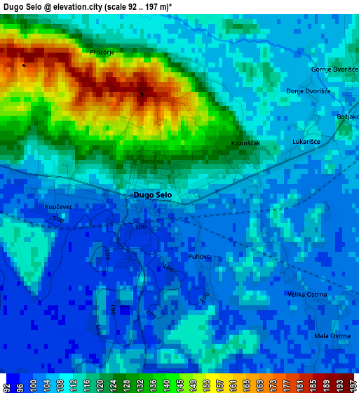
Below is the Elevation map of Dugo Selo, which displays elevation range with different colors. Scale of the first map is from 92 to 197 m (302 to 646 ft) with average elevation of 114.4 meters (=375 ft) [note 1]
These maps also provides idea of topography and contour of this city, they are displayed at different zoom levels. More info about maps, scale and edge coordinates you can find below images.
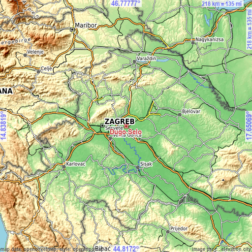
| \ | Map #1 | Topo.Map |
| Scale [m] | 92..197 m | × |
| Scale [ft] | 302..646 ft | × |
| Average | 114.4 m = 375 ft | × |
| Width | 6.81 km = 4.2 mi | 218 km = 135.5 mi |
| Height | 6.81 km = 4.2 mi | 218 km = 135.5 mi |
| ↑Max Latitude | 45.836735° | 46.77777° |
| Latitude at center | 45.80611° | 45.80611° |
| ↓Min Latitude | 45.775468° | 44.8172° |
| ← Min Longitude | 16.200495° | 14.83819° |
| Longitude center | 16.24444° | 16.24444° |
| →Max Longitude | 16.288385° | 17.65069° |
Nearby cities:
Cities around Dugo Selo sort by population:
• Sesvete elevation 142 m
10.3 km,  285°
285°
• Kašina 184 m
14.9 km,  321°
321°
• Mičevec 106 m
15.1 km,  245°
245°
• Dubrava 130 m
14.3 km,  282°
282°
• Velika Ostrna 104 m
3.5 km,  125°
125°
• Brckovljani 171 m
5.3 km,  54°
54°
• Gračec 106 m
6.4 km,  61°
61°
• Lupoglav 103 m
8 km,  97°
97°
• Lonjica 105 m
8.6 km, 50°
• Rakovec 119 m
15.1 km,  23°
23°
• Orle 97 m
13.7 km,  183°
183°
• Rugvica 98 m
7.8 km,  186°
186°
Multilingual:
 En español:
Dugo Selo elevación 113 m.
 En France:
Dugo Selo élévation 113 m.
 Auf Deutsch:
Dugo Selo höhe über dem Meeresspiegel ist 113 m.

Sources and notes:
- [note 1] Map square and city borders are not equal. Map elevation data is calculated only from area inside that square.
- [src 1] Elevation data from geonames database provided with same terms of usage.
- [src 2] The elevation map of Dugo Selo is generated using elevation data from NASA's 3 arcsec (90m) resolution SRTM data.
- [src 3] Base (background) map © OpenStreetMap contributors tiles are generated by Geofabrik and OpenTopoMap.
Copyright & License:
This Dugo Selo Elevation Map is licensed under CC BY-SA. You may reuse any part from this page, if you give a proper credit by linking to this URL:
 More info on terms of use page.