Azacualpa elevation
Azacualpa (Santa Bárbara), Honduras elevation is 373 meters and Azacualpa elevation in feet is 1224 ft above sea level [src 1]. Azacualpa is a populated place (feature code) with elevation that is 170 meters (558 ft) smaller than average city elevation in Honduras.
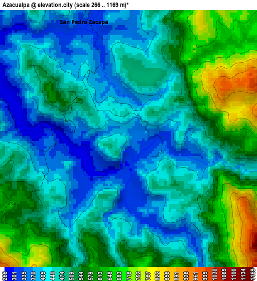
Below is the Elevation map of Azacualpa, which displays elevation range with different colors. Scale of the first map is from 266 to 1169 m (873 to 3835 ft) with average elevation of 491.9 meters (=1614 ft) [note 1]
These maps also provides idea of topography and contour of this city, they are displayed at different zoom levels. More info about maps, scale and edge coordinates you can find below images.
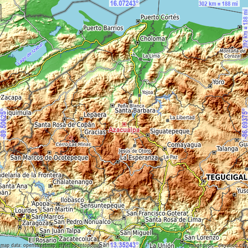
| \ | Map #1 | Topo.Map |
| Scale [m] | 266..1169 m | × |
| Scale [ft] | 873..3835 ft | × |
| Average | 491.9 m = 1614 ft | × |
| Width | 9.45 km = 5.9 mi | 302.4 km = 187.9 mi |
| Height | 9.45 km = 5.9 mi | 302.5 km = 188 mi |
| ↑Max Latitude | 14.759169° | 16.07243° |
| Latitude at center | 14.71667° | 14.71667° |
| ↓Min Latitude | 14.674162° | 13.35243° |
| ← Min Longitude | -88.143945° | -89.50625° |
| Longitude center | -88.1° | -88.1° |
| →Max Longitude | -88.056055° | -86.69375° |
Nearby cities:
Cities around Azacualpa sort by population:
• Las Vegas, Santa Barbara elevation 892 m
18 km,  8°
8°
• Taulabé 571 m
14.5 km,  97°
97°
• El Mochito 933 m
16.8 km, 6°
• Los Naranjos 768 m
21.1 km, 14°
• El Rincón 1231 m
23.3 km,  129°
129°
• Ceguaca 520 m
14.2 km,  310°
310°
• Ojos de Agua 1122 m
22.1 km, 125°
• El Socorro 1134 m
21.8 km,  115°
115°
• San José de Comayagua 716 m
7.4 km,  75°
75°
• San Pedro Zacapa 335 m
4.1 km,  334°
334°
• Río Bonito 1522 m
24 km, 76°
• Concepción del Sur 659 m
11.7 km,  322°
322°
Multilingual:
 En español:
Azacualpa elevación 373 m.
 En France:
Azacualpa élévation 373 m.
 Auf Deutsch:
Azacualpa höhe über dem Meeresspiegel ist 373 m.

Sources and notes:
- [note 1] Map square and city borders are not equal. Map elevation data is calculated only from area inside that square.
- [src 1] Elevation data from geonames database provided with same terms of usage.
- [src 2] The elevation map of Azacualpa is generated using elevation data from NASA's 3 arcsec (90m) resolution SRTM data.
- [src 3] Base (background) map © OpenStreetMap contributors tiles are generated by Geofabrik and OpenTopoMap.
Copyright & License:
This Azacualpa Elevation Map is licensed under CC BY-SA. You may reuse any part from this page, if you give a proper credit by linking to this URL:
 More info on terms of use page.