San Pedro Zacapa elevation
San Pedro Zacapa (Santa Bárbara), Honduras elevation is 335 meters and San Pedro Zacapa elevation in feet is 1099 ft above sea level [src 1]. San Pedro Zacapa is a populated place (feature code) with elevation that is 208 meters (682 ft) smaller than average city elevation in Honduras.
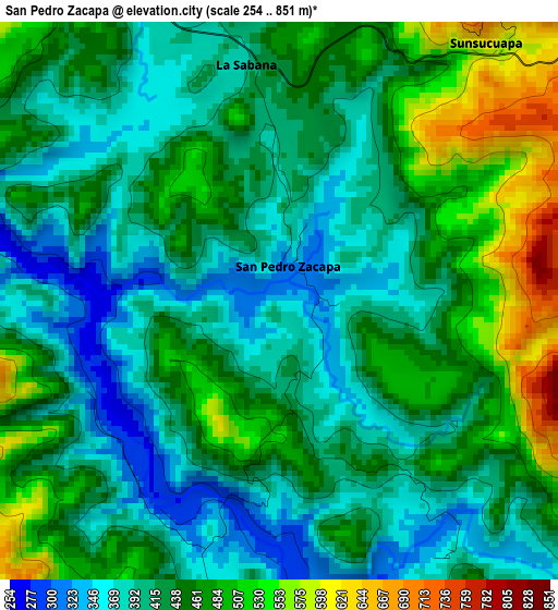
Below is the Elevation map of San Pedro Zacapa, which displays elevation range with different colors. Scale of the first map is from 254 to 851 m (833 to 2792 ft) with average elevation of 437 meters (=1434 ft) [note 1]
These maps also provides idea of topography and contour of this city, they are displayed at different zoom levels. More info about maps, scale and edge coordinates you can find below images.
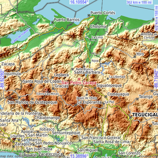
| \ | Map #1 | Topo.Map |
| Scale [m] | 254..851 m | × |
| Scale [ft] | 833..2792 ft | × |
| Average | 437 m = 1434 ft | × |
| Width | 9.45 km = 5.9 mi | 302.4 km = 187.9 mi |
| Height | 9.45 km = 5.9 mi | 302.4 km = 187.9 mi |
| ↑Max Latitude | 14.792493° | 16.10554° |
| Latitude at center | 14.75° | 14.75° |
| ↓Min Latitude | 14.707499° | 13.38596° |
| ← Min Longitude | -88.160615° | -89.52292° |
| Longitude center | -88.11667° | -88.11667° |
| →Max Longitude | -88.072725° | -86.71042° |
Nearby cities:
Cities around San Pedro Zacapa sort by population:
• Santa Bárbara elevation 256 m
22.8 km,  325°
325°
• Las Vegas, Santa Barbara 892 m
14.8 km,  17°
17°
• Taulabé 571 m
17.1 km,  109°
109°
• Arada 433 m
22.6 km,  299°
299°
• San Vicente Centenario 302 m
23.3 km,  309°
309°
• El Mochito 933 m
13.5 km, 15°
• Santa Rita 334 m
21.4 km, 329°
• Los Naranjos 768 m
18.2 km, 23°
• Azacualpa 373 m
4.1 km,  154°
154°
• Ceguaca 520 m
10.5 km, 301°
• San José de Comayagua 716 m
9.2 km,  101°
101°
• Concepción del Sur 659 m
7.7 km,  315°
315°
Multilingual:
 En español:
San Pedro Zacapa elevación 335 m.
 En France:
San Pedro Zacapa élévation 335 m.
 Auf Deutsch:
San Pedro Zacapa höhe über dem Meeresspiegel ist 335 m.

Sources and notes:
- [note 1] Map square and city borders are not equal. Map elevation data is calculated only from area inside that square.
- [src 1] Elevation data from geonames database provided with same terms of usage.
- [src 2] The elevation map of San Pedro Zacapa is generated using elevation data from NASA's 3 arcsec (90m) resolution SRTM data.
- [src 3] Base (background) map © OpenStreetMap contributors tiles are generated by Geofabrik and OpenTopoMap.
Copyright & License:
This San Pedro Zacapa Elevation Map is licensed under CC BY-SA. You may reuse any part from this page, if you give a proper credit by linking to this URL:
 More info on terms of use page.