Las Vegas, Santa Barbara elevation
Las Vegas, Santa Barbara (Santa Bárbara), Honduras elevation is 892 meters and Las Vegas, Santa Barbara elevation in feet is 2927 ft above sea level [src 1]. Las Vegas, Santa Barbara is a populated place (feature code) with elevation that is 349 meters (1145 ft) bigger than average city elevation in Honduras.
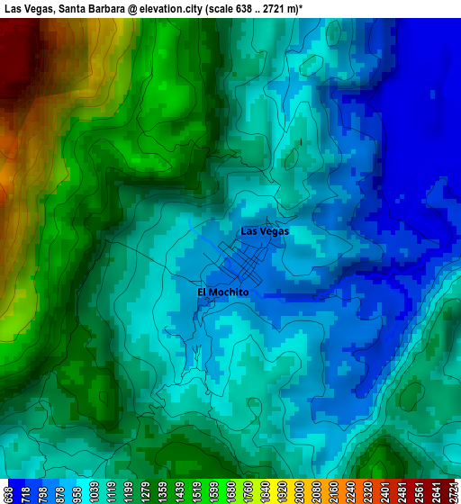
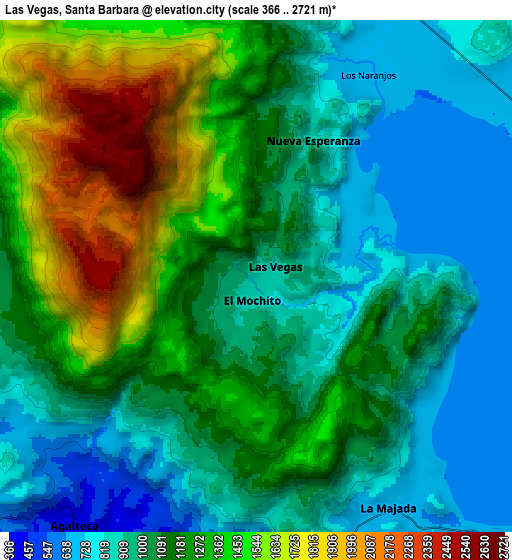
Below is the Elevation map of Las Vegas, Santa Barbara, which displays elevation range with different colors. Scale of the first map is from 638 to 2721 m (2093 to 8927 ft) with average elevation of 1169.3 meters (=3836 ft) [note 1]
These maps also provides idea of topography and contour of this city, they are displayed at different zoom levels. More info about maps, scale and edge coordinates you can find below images.
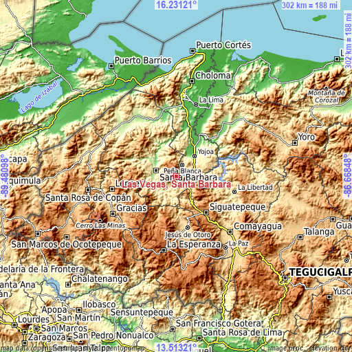
| \ | Map #1 | Map #2 | Topo.Map |
| Scale [m] | 638..2721 m | 366..2721 m | × |
| Scale [ft] | 2093..8927 ft | 1201..8927 ft | × |
| Average | 1169.3 m = 3836 ft | 1132.9 m = 3717 ft | × |
| Width | 9.44 km = 5.9 mi | 18.89 km = 11.7 mi | 302.2 km = 187.8 mi |
| Height | 9.44 km = 5.9 mi | 18.89 km = 11.7 mi | 302.2 km = 187.8 mi |
| ↑Max Latitude | 14.918958° | 14.961418° | 16.23121° |
| Latitude at center | 14.87649° | 14.87649° | 14.87649° |
| ↓Min Latitude | 14.834013° | 14.791529° | 13.51321° |
| ← Min Longitude | -88.118675° | -88.162621° | -89.48098° |
| Longitude center | -88.07473° | -88.07473° | -88.07473° |
| →Max Longitude | -88.030785° | -87.986839° | -86.66848° |
Nearby cities:
Cities around Las Vegas, Santa Barbara sort by population:
• Cañaveral elevation 506 m
13.4 km,  27°
27°
• El Mochito 933 m
1.4 km,  220°
220°
• Los Naranjos 768 m
3.7 km,  45°
45°
• El Tigre 649 m
11.7 km,  57°
57°
• La Guama 664 m
15.2 km,  87°
87°
• Ceguaca 520 m
15.9 km,  237°
237°
• Los Caminos 724 m
14.2 km, 54°
• San Luis de Planes 1495 m
13.4 km,  332°
332°
• Agua Azul 705 m
12.4 km,  68°
68°
• San Pedro Zacapa 335 m
14.8 km,  197°
197°
• Concepción del Sur 659 m
13 km,  229°
229°
• Agua Azul Rancho 648 m
13.7 km,  78°
78°
Multilingual:
 En español:
Las Vegas, Santa Barbara, Sauce elevación 892 m.
 En France:
Las Vegas, Santa Barbara élévation 892 m.
 Auf Deutsch:
Las Vegas, Santa Barbara höhe über dem Meeresspiegel ist 892 m.
 На русском:
Las Vegas, Santa Barbara высота над уровнем моря 892 м
Sources and notes:
- [note 1] Map square and city borders are not equal. Map elevation data is calculated only from area inside that square.
- [src 1] Elevation data from geonames database provided with same terms of usage.
- [src 2] The elevation map of Las Vegas, Santa Barbara is generated using elevation data from NASA's 3 arcsec (90m) resolution SRTM data.
- [src 3] Base (background) map © OpenStreetMap contributors tiles are generated by Geofabrik and OpenTopoMap.
Copyright & License:
This Las Vegas, Santa Barbara Elevation Map is licensed under CC BY-SA. You may reuse any part from this page, if you give a proper credit by linking to this URL:
 More info on terms of use page.