La Libertad elevation
La Libertad (Comayagua), Honduras elevation is 363 meters and La Libertad elevation in feet is 1191 ft above sea level [src 1]. La Libertad is a populated place (feature code) with elevation that is 180 meters (591 ft) smaller than average city elevation in Honduras.
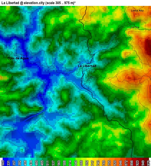
Below is the Elevation map of La Libertad, which displays elevation range with different colors. Scale of the first map is from 305 to 975 m (1001 to 3199 ft) with average elevation of 530 meters (=1739 ft) [note 1]
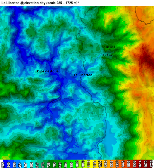
These maps also provides idea of topography and contour of this city, they are displayed at different zoom levels. More info about maps, scale and edge coordinates you can find below images.
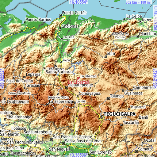
| \ | Map #1 | Map #2 | Topo.Map |
| Scale [m] | 305..975 m | 285..1725 m | × |
| Scale [ft] | 1001..3199 ft | 935..5659 ft | × |
| Average | 530 m = 1739 ft | 697.7 m = 2289 ft | × |
| Width | 9.45 km = 5.9 mi | 18.9 km = 11.7 mi | 302.4 km = 187.9 mi |
| Height | 9.45 km = 5.9 mi | 18.9 km = 11.7 mi | 302.4 km = 187.9 mi |
| ↑Max Latitude | 14.792493° | 14.834978° | 16.10554° |
| Latitude at center | 14.75° | 14.75° | 14.75° |
| ↓Min Latitude | 14.707499° | 14.664989° | 13.38596° |
| ← Min Longitude | -87.660615° | -87.704561° | -89.02292° |
| Longitude center | -87.61667° | -87.61667° | -87.61667° |
| →Max Longitude | -87.572725° | -87.528779° | -86.21042° |
Nearby cities:
Cities around La Libertad sort by population:
• Las Lajas elevation 454 m
14.8 km,  284°
284°
• El Rosario 460 m
17.1 km,  289°
289°
• San Luis 719 m
21.5 km,  90°
90°
• San Jerónimo 452 m
13.1 km,  172°
172°
• El Rancho 984 m
14.6 km,  120°
120°
• Concepción de Guasistagua 474 m
17.1 km,  192°
192°
• El Sauce 595 m
25.2 km, 192°
• Esquías 742 m
26.9 km, 93°
• Cerro Blanco 1189 m
20.2 km,  242°
242°
• Jamalteca 479 m
6.6 km,  147°
147°
• San Antonio de la Cuesta 452 m
13.1 km, 172°
• El Agua Dulcita 1067 m
15.4 km,  248°
248°
Multilingual:
 En español:
La Libertad elevación 363 m.
 En France:
La Libertad élévation 363 m.
 Auf Deutsch:
La Libertad höhe über dem Meeresspiegel ist 363 m.

Sources and notes:
- [note 1] Map square and city borders are not equal. Map elevation data is calculated only from area inside that square.
- [src 1] Elevation data from geonames database provided with same terms of usage.
- [src 2] The elevation map of La Libertad is generated using elevation data from NASA's 3 arcsec (90m) resolution SRTM data.
- [src 3] Base (background) map © OpenStreetMap contributors tiles are generated by Geofabrik and OpenTopoMap.
Copyright & License:
This La Libertad Elevation Map is licensed under CC BY-SA. You may reuse any part from this page, if you give a proper credit by linking to this URL:
 More info on terms of use page.