Las Lajas elevation
Las Lajas (Comayagua), Honduras elevation is 454 meters and Las Lajas elevation in feet is 1490 ft above sea level [src 1]. Las Lajas is a populated place (feature code) with elevation that is 89 meters (292 ft) smaller than average city elevation in Honduras.
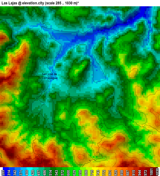
Below is the Elevation map of Las Lajas, which displays elevation range with different colors. Scale of the first map is from 285 to 1030 m (935 to 3379 ft) with average elevation of 590.7 meters (=1938 ft) [note 1]
These maps also provides idea of topography and contour of this city, they are displayed at different zoom levels. More info about maps, scale and edge coordinates you can find below images.
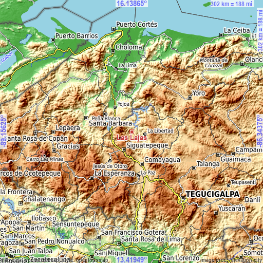
| \ | Map #1 | Topo.Map |
| Scale [m] | 285..1030 m | × |
| Scale [ft] | 935..3379 ft | × |
| Average | 590.7 m = 1938 ft | × |
| Width | 9.45 km = 5.9 mi | 302.3 km = 187.8 mi |
| Height | 9.45 km = 5.9 mi | 302.4 km = 187.9 mi |
| ↑Max Latitude | 14.825816° | 16.13865° |
| Latitude at center | 14.78333° | 14.78333° |
| ↓Min Latitude | 14.740835° | 13.41949° |
| ← Min Longitude | -87.793945° | -89.15625° |
| Longitude center | -87.75° | -87.75° |
| →Max Longitude | -87.706055° | -86.34375° |
Nearby cities:
Cities around Las Lajas sort by population:
• Siguatepeque elevation 1079 m
22.3 km,  203°
203°
• La Libertad 363 m
14.8 km,  104°
104°
• El Rosario 460 m
2.6 km,  315°
315°
• San Jerónimo 452 m
23.2 km,  135°
135°
• Concepción de Guasistagua 474 m
23 km,  152°
152°
• La Guama 664 m
22.6 km,  299°
299°
• Cerro Blanco 1189 m
13.5 km, 195°
• Jamalteca 479 m
20.2 km,  117°
117°
• El Socorro 1134 m
24.5 km,  227°
227°
• Río Bonito 1522 m
14.5 km,  262°
262°
• San Antonio de la Cuesta 452 m
23.2 km, 135°
• El Agua Dulcita 1067 m
9.3 km,  180°
180°
Multilingual:
 En español:
Las Lajas elevación 454 m.
 En France:
Las Lajas élévation 454 m.
 Auf Deutsch:
Las Lajas höhe über dem Meeresspiegel ist 454 m.

Sources and notes:
- [note 1] Map square and city borders are not equal. Map elevation data is calculated only from area inside that square.
- [src 1] Elevation data from geonames database provided with same terms of usage.
- [src 2] The elevation map of Las Lajas is generated using elevation data from NASA's 3 arcsec (90m) resolution SRTM data.
- [src 3] Base (background) map © OpenStreetMap contributors tiles are generated by Geofabrik and OpenTopoMap.
Copyright & License:
This Las Lajas Elevation Map is licensed under CC BY-SA. You may reuse any part from this page, if you give a proper credit by linking to this URL:
 More info on terms of use page.