Siguatepeque elevation
Siguatepeque (Comayagua), Honduras elevation is 1079 meters and Siguatepeque elevation in feet is 3540 ft above sea level [src 1]. Siguatepeque is a populated place (feature code) with elevation that is 536 meters (1759 ft) bigger than average city elevation in Honduras.
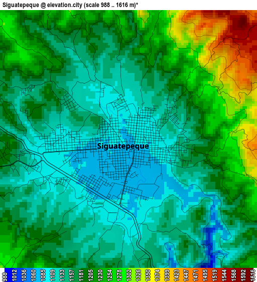
Below is the Elevation map of Siguatepeque, which displays elevation range with different colors. Scale of the first map is from 988 to 1616 m (3241 to 5302 ft) with average elevation of 1183.4 meters (=3883 ft) [note 1]
These maps also provides idea of topography and contour of this city, they are displayed at different zoom levels. More info about maps, scale and edge coordinates you can find below images.
| \ | Map #1 | Map #2 | Topo.Map |
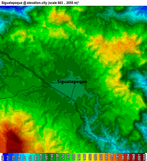
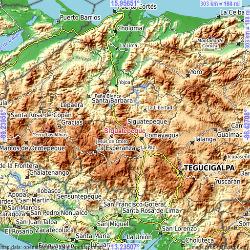
| Scale [m] | 988..1616 m | 663..2055 m | × |
| Scale [ft] | 3241..5302 ft | 2175..6742 ft | × |
| Average | 1183.4 m = 3883 ft | 1242.6 m = 4077 ft | × |
| Width | 9.46 km = 5.9 mi | 18.91 km = 11.8 mi | 302.6 km = 188 mi |
| Height | 9.46 km = 5.9 mi | 18.91 km = 11.8 mi | 302.6 km = 188 mi |
| ↑Max Latitude | 14.642522° | 14.685036° | 15.95651° |
| Latitude at center | 14.6° | 14.6° | 14.6° |
| ↓Min Latitude | 14.55747° | 14.514931° | 13.23507° |
| ← Min Longitude | -87.877275° | -87.921221° | -89.23958° |
| Longitude center | -87.83333° | -87.83333° | -87.83333° |
| →Max Longitude | -87.789385° | -87.745439° | -86.42708° |
Nearby cities:
Cities around Siguatepeque sort by population:
• Taulabé elevation 571 m
18.1 km,  307°
307°
• El Rincón 1231 m
10.9 km,  260°
260°
• Concepción de Guasistagua 474 m
19.7 km,  90°
90°
• El Sauce 595 m
19.7 km,  113°
113°
• El Porvenir 1157 m
5.7 km,  250°
250°
• Potrerillos 1274 m
6.6 km,  212°
212°
• Cerro Blanco 1189 m
9.2 km,  35°
35°
• Ojos de Agua 1122 m
10.8 km,  270°
270°
• Aguas del Padre 1249 m
6.5 km,  235°
235°
• El Socorro 1134 m
9.7 km,  292°
292°
• Río Bonito 1522 m
19.3 km,  343°
343°
• El Agua Dulcita 1067 m
14.3 km, 38°
Multilingual:
 En español:
Siguatepeque elevación 1079 m.
 En France:
Siguatepeque élévation 1079 m.
 Auf Deutsch:
Siguatepeque höhe über dem Meeresspiegel ist 1079 m.

Sources and notes:
- [note 1] Map square and city borders are not equal. Map elevation data is calculated only from area inside that square.
- [src 1] Elevation data from geonames database provided with same terms of usage.
- [src 2] The elevation map of Siguatepeque is generated using elevation data from NASA's 3 arcsec (90m) resolution SRTM data.
- [src 3] Base (background) map © OpenStreetMap contributors tiles are generated by Geofabrik and OpenTopoMap.
Copyright & License:
This Siguatepeque Elevation Map is licensed under CC BY-SA. You may reuse any part from this page, if you give a proper credit by linking to this URL:
 More info on terms of use page.