El Sauce elevation
El Sauce (Comayagua), Honduras elevation is 595 meters and El Sauce elevation in feet is 1952 ft above sea level [src 1]. El Sauce is a populated place (feature code) with elevation that is 52 meters (171 ft) bigger than average city elevation in Honduras.
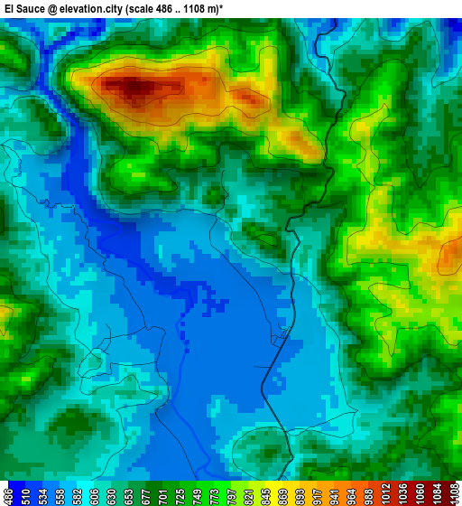
Below is the Elevation map of El Sauce, which displays elevation range with different colors. Scale of the first map is from 486 to 1108 m (1594 to 3635 ft) with average elevation of 667 meters (=2188 ft) [note 1]
These maps also provides idea of topography and contour of this city, they are displayed at different zoom levels. More info about maps, scale and edge coordinates you can find below images.
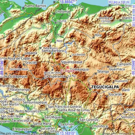
| \ | Map #1 | Topo.Map |
| Scale [m] | 486..1108 m | × |
| Scale [ft] | 1594..3635 ft | × |
| Average | 667 m = 2188 ft | × |
| Width | 9.46 km = 5.9 mi | 302.7 km = 188.1 mi |
| Height | 9.46 km = 5.9 mi | 302.7 km = 188.1 mi |
| ↑Max Latitude | 14.571036° | 15.88547° |
| Latitude at center | 14.5285° | 14.5285° |
| ↓Min Latitude | 14.485956° | 13.16315° |
| ← Min Longitude | -87.709655° | -89.07196° |
| Longitude center | -87.66571° | -87.66571° |
| →Max Longitude | -87.621765° | -86.25946° |
Nearby cities:
Cities around El Sauce sort by population:
• Comayagua elevation 593 m
9.1 km,  160°
160°
• Siguatepeque 1079 m
19.7 km,  293°
293°
• Ajuterique 647 m
16.6 km,  192°
192°
• Lejamaní 658 m
18.4 km, 191°
• San Jerónimo 452 m
13.6 km,  31°
31°
• Concepción de Guasistagua 474 m
8.1 km,  12°
12°
• Potrerillos 1274 m
21.8 km,  276°
276°
• Cerro Blanco 1189 m
19.9 km,  320°
320°
• Jamalteca 479 m
21 km,  24°
24°
• Valle de Ángeles 687 m
4.7 km,  132°
132°
• San Antonio de la Cuesta 452 m
13.6 km, 31°
• El Agua Dulcita 1067 m
21.1 km,  334°
334°
Multilingual:
 En español:
El Sauce elevación 595 m.
 En France:
El Sauce élévation 595 m.
 Auf Deutsch:
El Sauce höhe über dem Meeresspiegel ist 595 m.

Sources and notes:
- [note 1] Map square and city borders are not equal. Map elevation data is calculated only from area inside that square.
- [src 1] Elevation data from geonames database provided with same terms of usage.
- [src 2] The elevation map of El Sauce is generated using elevation data from NASA's 3 arcsec (90m) resolution SRTM data.
- [src 3] Base (background) map © OpenStreetMap contributors tiles are generated by Geofabrik and OpenTopoMap.
Copyright & License:
This El Sauce Elevation Map is licensed under CC BY-SA. You may reuse any part from this page, if you give a proper credit by linking to this URL:
 More info on terms of use page.