San Luis elevation
San Luis (Comayagua), Honduras elevation is 719 meters and San Luis elevation in feet is 2359 ft above sea level [src 1]. San Luis is a populated place (feature code) with elevation that is 176 meters (577 ft) bigger than average city elevation in Honduras.
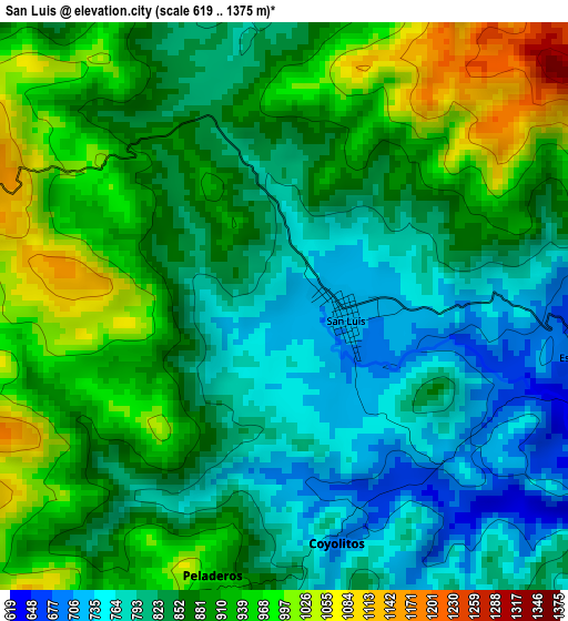
Below is the Elevation map of San Luis, which displays elevation range with different colors. Scale of the first map is from 619 to 1375 m (2031 to 4511 ft) with average elevation of 868.7 meters (=2850 ft) [note 1]
These maps also provides idea of topography and contour of this city, they are displayed at different zoom levels. More info about maps, scale and edge coordinates you can find below images.
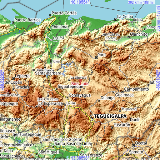
| \ | Map #1 | Topo.Map |
| Scale [m] | 619..1375 m | × |
| Scale [ft] | 2031..4511 ft | × |
| Average | 868.7 m = 2850 ft | × |
| Width | 9.45 km = 5.9 mi | 302.4 km = 187.9 mi |
| Height | 9.45 km = 5.9 mi | 302.4 km = 187.9 mi |
| ↑Max Latitude | 14.792493° | 16.10554° |
| Latitude at center | 14.75° | 14.75° |
| ↓Min Latitude | 14.707499° | 13.38596° |
| ← Min Longitude | -87.460615° | -88.82292° |
| Longitude center | -87.41667° | -87.41667° |
| →Max Longitude | -87.372725° | -86.01042° |
Nearby cities:
Cities around San Luis sort by population:
• La Libertad elevation 363 m
21.5 km,  270°
270°
• Minas de Oro 1004 m
9.1 km,  52°
52°
• Sulaco 419 m
24.6 km,  41°
41°
• Vallecillo 1009 m
26 km,  176°
176°
• San Jerónimo 452 m
23.6 km,  236°
236°
• El Rancho 984 m
11.6 km,  230°
230°
• Esquías 742 m
5.7 km,  109°
109°
• El Guantillo 938 m
20.9 km,  143°
143°
• Mata de Plátano 1095 m
22 km, 139°
• Jamalteca 479 m
18.8 km,  252°
252°
• San José del Potrero 659 m
17.1 km,  57°
57°
• San Antonio de la Cuesta 452 m
23.6 km, 236°
Multilingual:
 En español:
San Luis elevación 719 m.
 En France:
San Luis élévation 719 m.
 Auf Deutsch:
San Luis höhe über dem Meeresspiegel ist 719 m.

Sources and notes:
- [note 1] Map square and city borders are not equal. Map elevation data is calculated only from area inside that square.
- [src 1] Elevation data from geonames database provided with same terms of usage.
- [src 2] The elevation map of San Luis is generated using elevation data from NASA's 3 arcsec (90m) resolution SRTM data.
- [src 3] Base (background) map © OpenStreetMap contributors tiles are generated by Geofabrik and OpenTopoMap.
Copyright & License:
This San Luis Elevation Map is licensed under CC BY-SA. You may reuse any part from this page, if you give a proper credit by linking to this URL:
 More info on terms of use page.