El Guantillo elevation
El Guantillo (Francisco Morazán), Honduras elevation is 938 meters and El Guantillo elevation in feet is 3077 ft above sea level [src 1]. El Guantillo is a populated place (feature code) with elevation that is 395 meters (1296 ft) bigger than average city elevation in Honduras.
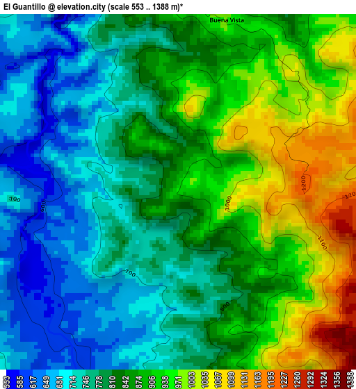
Below is the Elevation map of El Guantillo, which displays elevation range with different colors. Scale of the first map is from 553 to 1388 m (1814 to 4554 ft) with average elevation of 836.7 meters (=2745 ft) [note 1]
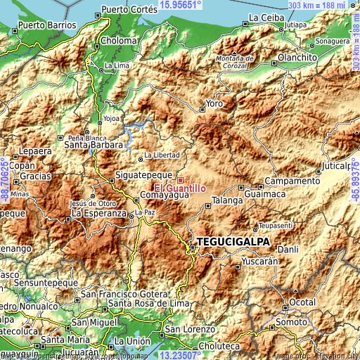
These maps also provides idea of topography and contour of this city, they are displayed at different zoom levels. More info about maps, scale and edge coordinates you can find below images.
| \ | Map #1 | Topo.Map |
| Scale [m] | 553..1388 m | × |
| Scale [ft] | 1814..4554 ft | × |
| Average | 836.7 m = 2745 ft | × |
| Width | 9.46 km = 5.9 mi | 302.6 km = 188 mi |
| Height | 9.46 km = 5.9 mi | 302.6 km = 188 mi |
| ↑Max Latitude | 14.642522° | 15.95651° |
| Latitude at center | 14.6° | 14.6° |
| ↓Min Latitude | 14.55747° | 13.23507° |
| ← Min Longitude | -87.343945° | -88.70625° |
| Longitude center | -87.3° | -87.3° |
| →Max Longitude | -87.256055° | -85.89375° |
Nearby cities:
Cities around El Guantillo sort by population:
• Minas de Oro elevation 1004 m
22.9 km,  346°
346°
• El Suyatal 806 m
12.9 km,  135°
135°
• Vallecillo 1009 m
14.2 km,  229°
229°
• San Luis 719 m
20.9 km,  323°
323°
• El Pedernal 673 m
22.6 km,  60°
60°
• Quebradas 736 m
12.4 km,  205°
205°
• Esquías 742 m
16.5 km,  334°
334°
• El Escanito 609 m
22.8 km,  70°
70°
• Mata de Plátano 1095 m
1.8 km,  90°
90°
• El Guante 881 m
22.2 km,  104°
104°
• Cedros 927 m
19.7 km, 90°
• Agalteca 724 m
17.1 km,  167°
167°
Multilingual:
 En español:
El Guantillo elevación 938 m.
 En France:
El Guantillo élévation 938 m.
 Auf Deutsch:
El Guantillo höhe über dem Meeresspiegel ist 938 m.

Sources and notes:
- [note 1] Map square and city borders are not equal. Map elevation data is calculated only from area inside that square.
- [src 1] Elevation data from geonames database provided with same terms of usage.
- [src 2] The elevation map of El Guantillo is generated using elevation data from NASA's 3 arcsec (90m) resolution SRTM data.
- [src 3] Base (background) map © OpenStreetMap contributors tiles are generated by Geofabrik and OpenTopoMap.
Copyright & License:
This El Guantillo Elevation Map is licensed under CC BY-SA. You may reuse any part from this page, if you give a proper credit by linking to this URL:
 More info on terms of use page.