Sulaco elevation
Sulaco (Yoro), Honduras elevation is 419 meters and Sulaco elevation in feet is 1375 ft above sea level [src 1]. Sulaco is a populated place (feature code) with elevation that is 124 meters (407 ft) smaller than average city elevation in Honduras.
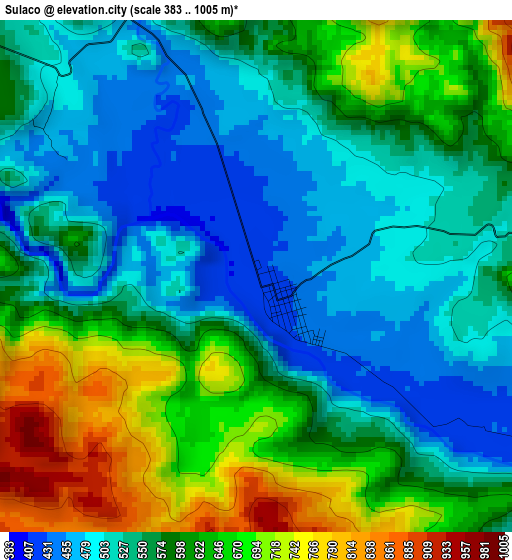
Below is the Elevation map of Sulaco, which displays elevation range with different colors. Scale of the first map is from 383 to 1005 m (1257 to 3297 ft) with average elevation of 577.5 meters (=1895 ft) [note 1]
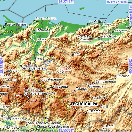
These maps also provides idea of topography and contour of this city, they are displayed at different zoom levels. More info about maps, scale and edge coordinates you can find below images.
| \ | Map #1 | Topo.Map |
| Scale [m] | 383..1005 m | × |
| Scale [ft] | 1257..3297 ft | × |
| Average | 577.5 m = 1895 ft | × |
| Width | 9.44 km = 5.9 mi | 302.2 km = 187.8 mi |
| Height | 9.44 km = 5.9 mi | 302.2 km = 187.8 mi |
| ↑Max Latitude | 14.95913° | 16.27112° |
| Latitude at center | 14.91667° | 14.91667° |
| ↓Min Latitude | 14.874201° | 13.55364° |
| ← Min Longitude | -87.310615° | -88.67292° |
| Longitude center | -87.26667° | -87.26667° |
| →Max Longitude | -87.222725° | -85.86042° |
Nearby cities:
Cities around Sulaco sort by population:
• Minas de Oro elevation 1004 m
15.8 km,  214°
214°
• Yorito 787 m
16.8 km,  353°
353°
• San Luis 719 m
24.6 km,  221°
221°
• El Bálsamo 828 m
27.2 km,  307°
307°
• Ayapa 642 m
23.8 km,  24°
24°
• Lomitas 613 m
21.1 km,  14°
14°
• Marale 758 m
13.1 km,  106°
106°
• Esquías 742 m
23 km, 207°
• La Trinidad 625 m
21.6 km, 19°
• Las Vegas 512 m
22.6 km,  299°
299°
• Paujiles 1324 m
22.3 km,  336°
336°
• San José del Potrero 659 m
9.4 km,  190°
190°
Multilingual:
 En español:
Sulaco elevación 419 m.
 En France:
Sulaco élévation 419 m.


Sources and notes:
- [note 1] Map square and city borders are not equal. Map elevation data is calculated only from area inside that square.
- [src 1] Elevation data from geonames database provided with same terms of usage.
- [src 2] The elevation map of Sulaco is generated using elevation data from NASA's 3 arcsec (90m) resolution SRTM data.
- [src 3] Base (background) map © OpenStreetMap contributors tiles are generated by Geofabrik and OpenTopoMap.
Copyright & License:
This Sulaco Elevation Map is licensed under CC BY-SA. You may reuse any part from this page, if you give a proper credit by linking to this URL:
 More info on terms of use page.