San Juan de Flores elevation
San Juan de Flores (Francisco Morazán), Honduras elevation is 742 meters and San Juan de Flores elevation in feet is 2434 ft above sea level [src 1]. San Juan de Flores is a populated place (feature code) with elevation that is 199 meters (653 ft) bigger than average city elevation in Honduras.
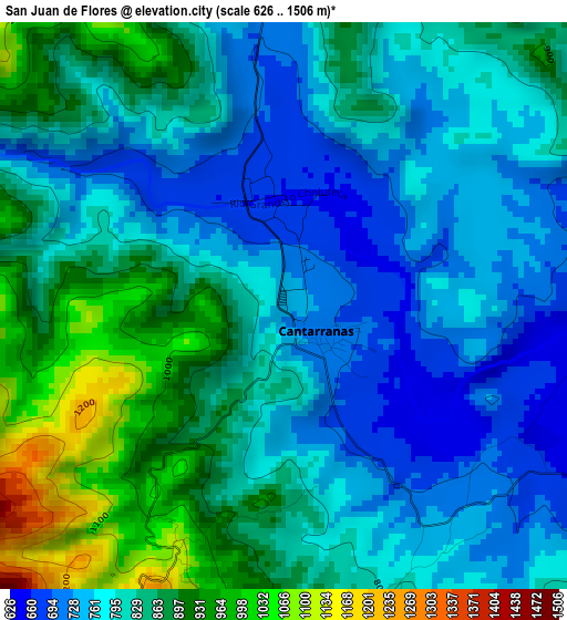
Below is the Elevation map of San Juan de Flores, which displays elevation range with different colors. Scale of the first map is from 626 to 1506 m (2054 to 4941 ft) with average elevation of 820.2 meters (=2691 ft) [note 1]
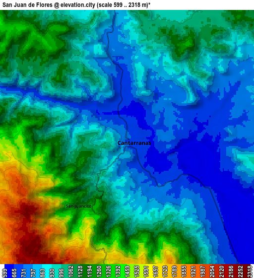
These maps also provides idea of topography and contour of this city, they are displayed at different zoom levels. More info about maps, scale and edge coordinates you can find below images.
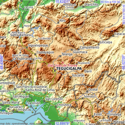
| \ | Map #1 | Map #2 | Topo.Map |
| Scale [m] | 626..1506 m | 599..2318 m | × |
| Scale [ft] | 2054..4941 ft | 1965..7605 ft | × |
| Average | 820.2 m = 2691 ft | 1034.1 m = 3393 ft | × |
| Width | 9.47 km = 5.9 mi | 18.94 km = 11.8 mi | 303 km = 188.3 mi |
| Height | 9.47 km = 5.9 mi | 18.94 km = 11.8 mi | 303.1 km = 188.3 mi |
| ↑Max Latitude | 14.309256° | 14.351834° | 15.62531° |
| Latitude at center | 14.26667° | 14.26667° | 14.26667° |
| ↓Min Latitude | 14.224076° | 14.181474° | 12.89979° |
| ← Min Longitude | -87.077275° | -87.121221° | -88.43958° |
| Longitude center | -87.03333° | -87.03333° | -87.03333° |
| →Max Longitude | -86.989385° | -86.945439° | -85.62708° |
Nearby cities:
Cities around San Juan de Flores sort by population:
• Tegucigalpa elevation 944 m
27.8 km,  222°
222°
• Talanga 810 m
15.8 km,  340°
340°
• Villa de San Francisco 777 m
13.2 km,  147°
147°
• Valle de Ángeles 1278 m
13 km,  180°
180°
• Morocelí 625 m
24.5 km,  132°
132°
• La Ermita 770 m
22.5 km,  350°
350°
• Villa Nueva 1358 m
28.1 km,  202°
202°
• Santa Lucía 1550 m
20.6 km,  205°
205°
• Río Abajo 1027 m
22.7 km,  240°
240°
• Cofradía 1131 m
17.1 km,  251°
251°
• El Chimbo 1213 m
17.3 km, 211°
• El Terrero 1168 m
22.5 km,  189°
189°
Multilingual:
 En español:
San Juan de Flores elevación 742 m.
 En France:
San Juan de Flores élévation 742 m.
 Auf Deutsch:
San Juan de Flores höhe über dem Meeresspiegel ist 742 m.
 На русском:
San Juan de Flores высота над уровнем моря 742 м
Sources and notes:
- [note 1] Map square and city borders are not equal. Map elevation data is calculated only from area inside that square.
- [src 1] Elevation data from geonames database provided with same terms of usage.
- [src 2] The elevation map of San Juan de Flores is generated using elevation data from NASA's 3 arcsec (90m) resolution SRTM data.
- [src 3] Base (background) map © OpenStreetMap contributors tiles are generated by Geofabrik and OpenTopoMap.
Copyright & License:
This San Juan de Flores Elevation Map is licensed under CC BY-SA. You may reuse any part from this page, if you give a proper credit by linking to this URL:
 More info on terms of use page.